
Showing posts with label Brooklyn. Show all posts
Showing posts with label Brooklyn. Show all posts
22 April 2020
BROOKLYN REBUS REDUX
Here's another simple puzzle. Can you name the two-word neighborhood of Brooklyn, New York? Again, ignore the fact that I drew an octopus but it does play a role in the puzzle because of the gear it's in.

21 April 2020
BROOKLYN REBUS
I love puzzles, especially those that involve interpreting words or symbols that mean something else. For example, a cluster of cloud with the number 9 means cloud nine, as in to be on cloud nine, meaning to be extremely happy. Rebus may be one way to name such puzzles. With the ongoing quarantine in NYC and elsewhere, I played a few already and finally decided to make one myself. The puzzles I played have a whole grid of items, hopefully as I devote more time into making my original puzzles I will have a whole grid to share too. I have a fascination with octopus and have a whole album in Facebook devoted to sighting of them, so my first thought is to both entertain my octopus fans and be unique with my puzzles by always include the creature in my drawings.
Can you guess the neighborhood of Brooklyn, New York depicted in the drawing below?

Can you guess the neighborhood of Brooklyn, New York depicted in the drawing below?

20 September 2019
I'M WALKIN' HERE! I'M WALKIN' HERE!
And I sure walked a lot. New York City is a pedestrian paradise, in some ways. Yes, there are many rude, or even evil, car-drivers and then there are also many lawless cyclists ready to knock down pedestrians. In general, the great thing is one can walk almost everywhere. Or run, for that matter. I used to be an avid runner, got up early in the morning to run a few miles, wash off the dirt, then go to work. Then I started working at a job that required a car commute, a commute that would be so much worse if I didn't leave the house by a certain hour in the morning. That meant no more running in the morning before going to work. I was able to walk a lot, before work or after, or during lunch breaks. I still ran on the weekends, or during the week on those rare days when I finished work early.
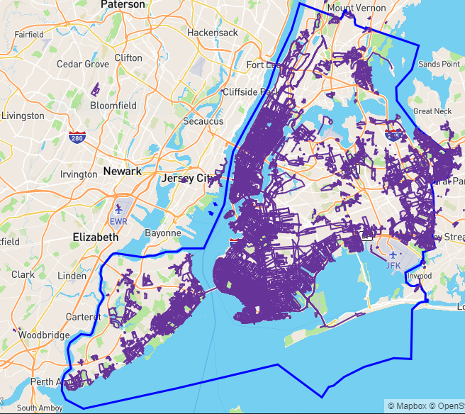
Wouldn't it be nice to visualize all that walking and running on one map? Yes, and that's exactly what the web site CityStrides offer. It is free to use, with some extra features if you pay for a subscription. There are a few subscription tiers, I think anyone with a job should be able to afford the fee, just to support the work of the one man who runs the whole thing.
Below is my map of New York City, i.e. the five boroughs (The Bronx, Manhattan, Brook, Queens, and Staten Island) combined. My activities only cover about 25% of the entire NYC so there is much work left to be done. There is no fame or fortune to claim, just bragging rights among friends or friendly competitors. A few people already covered the entire city, measured by some other means. The movie The World Before Your Feet chronicles one such feat. The guy in that movie didn't have a full-time job and achieved the goal in about six years. I have other obligations to satisfy so for now I am happy with my slow progress.
11 February 2019
PPTC GROUP RUN - LOVE RUN 2019
Elizabeth Barrett Browning once wrote, "How do I love thee? Let me count the miles." And count the miles I did, with nine other runners.
Check out the Relive video
From the practice run I had a few weeks ago, I learned that the "i" looks better, less slanted at the bottom, if I start the run on the side of the Grand Army Plaza arch. We would basically run along Eastern Parkway, so the closer I was, vertically, to the bottom of the parkway the better.
While doing the left side of the heart, Strava almost messed me up. I just paused it while at the intersection of Park Place, Grand Avenue, and Washington Avenue, ran around the corner of Prospect Place and Grand Avenue, as I was about to Resume, I noticed that the Pause point was actually at Sterling Place and Washington Avenue. Strava does act weird sometimes, in this case it was a block behind where I actually was. Being the perfectionist run-artist that I am, I ran back the intersection of Park, Grand, and Washington, press Resume, waited a few seconds, then Paused again. Ran around the corner of Prospect and Grand, verified that all was good, then pressed Resume. And that's how we had the first relatively rounder corner of the heart. There were many more Pause and Resume, each time I paused the run to show my running mates the progress.
Also from the practice run, I realized that I should take advantage of the width of Eastern Parkway to make a rounder bottom of the heart. It came out pretty good. The group had to be careful crossing the wide Parkway, NOT at the zebra crossing, but we did wait for red lights, so it worked out. Very worthwhile, as we all know round-bottomed hearts make the rocking world go round.


03 February 2019
DIY I {heart} U
While I would love to have you join me at the Love Run on Saturday the 9th of February, 8:30 A.M., by Brooklyn's Grand Army Plaza, should the timing not good for you, here's a turn-by-turn direction on how to get it done. One slight change I will implement is the start will be on the northern side of Union Street, where the tail of the first arrow is. (The run starts from the green hexagon and ends at the red hexagon.) The baseline of the letters and symbol is Eastern Parkway so we might as well start as close to it as possible, vertically.
The letter P means you pause your watch or app at those locations, then resume recording where the letter R appears. Most of the time, the app or watch would be fooled into drawing a straight line between the two points, so we get a less blocky heart. One time I tried to spell MISSY but Strava at the last minute changed the Y into a T, so it really happened before. Hopefully it won't happen to you.
There ya go, have fun spelling "I {heart} U" on your own. Some people may be able to learn guitar by watching YouTube videos, but others may need Dan Smith to teach them, so no guarantee my little turn-by-turn instruction will get you there but give it a shot and share with me the outcome.

02 February 2019
I {HEART} U
If spreading love is the Brooklyn way, you can do it with me this coming Saturday the 9th of February. I will lead a run for the Prospect Park Track Club that will spell out "I {heart} U", as shown below. It'll cover about 4 miles, at least that's what Strava recorded when I did the test run last week. I made a sleight of hand, or rather sleight of foot, to make the lines that seem to cut through the block, like the right side of the heart symbol. I suspect Strava measured the distance along the straight line. We'll actually run along the two legs of the right triangle, so it's a longer route. The shortest distance between two points if a straight line, ya know? See, who said high school math/trig isn't useful?
PPTC hosts the event but it's free to the public. Your fellow runners may encourage you to join the club and we may retire to some cafe to grab a much-deserved breakfast, Dutch treat. An hour or so of your time is all you'll spend.
See you 8:30 A.M. at the corner of Union Street and Prospect Park West on Saturday the 9th of February!

01 January 2018
THIS WEEK IN CITYSTRIDES: BROOKLYN, NEW YORK AT 20%
Happy New Year!
I started the new year by volunteering for my track club's handicap race and pot luck party. One aspect of the event is a storytelling session after the race, with anecdotes about the club's past and current members. I especially like the story about them interacting with Fred Lebow - yes, the Fred Lebow of New York Road Runners Club fame.
The last week of the year I had a few time-off days to burn, it was a use-it-or-lose-it situation. Everyday of the week was cold but I wanted to maintain my tiny lead for New York, NY* in CityStrides so everyday I was out there running a few miles to add nodes. Every little bit helps and currently I'm at 20% completed for Brooklyn and 9% completed for New York, NY. Deep down I know that, because CityStrides round off to the nearest integer, I don't really have 20% and 9% but more of 19.x% and 8.y%, but it looks better this way.
In case you wonder, CityStrides has a little gadget at the upper left corner used for rotating or tilting the map. I used it to achieve the view below. Brooklyn, NY's height is longer than its width so that in order to include its northernmost portion, the area below Newtown Creek, I would normally have to zoom out further. However, by tilting the map along the Z-axis you can see further without zooming out further.

* New York, NY in the CityStrides sphere means New York City itself, comprising of the five boroughs: Manhattan, Queens, Brooklyn, the Bronx, and Staten Island. It does not mean the New York, NY as used by the United States Postal Service, which means just Manhattan and nearby islands plus Marble Hill, which is physically part of the Bronx but was originally part of Manhattan Island.
10 April 2016
MARINE PARK IS ON THE MAP
I have good news and bad news. Good news is I am still on this ambitious project of "mapping" every Brooklyn neighborhood by running and spelling their names, in that neighborhood. Or somewhere close. Just this weekend I finally completed "Marine Park". The bad news is I took too long to do this Garmin web site finally got rid of Classic view so now any additional maps will look slightly different. "Marine Park" is one such. The lines are darker, which is fine, but luckily the underlying map is still the same. Whew. All the more reason I should hurry up and finish this before any more changes, whether with Garmin.com or with my own health. You never know, one day you can be healthy and all, the next day you can no longer run.
For "Marine Park", I broke one of my rules about running. I hate driving and when I go for a run, I absolutely don't want to drive somewhere just to run there. But I have to be realistic now. While I can certainly drive to Marine Park to do the run, it is just much faster when I drive. And there is plenty of parking at the park, so I really have no excuse not to. With this executive decision made, I plan to drive to Prospect Park etc some weekend day, really early in the morning for a better chance of finding a parking spot, and be done with those faraway places. Let's hope the map will be filled soon!


10 January 2016
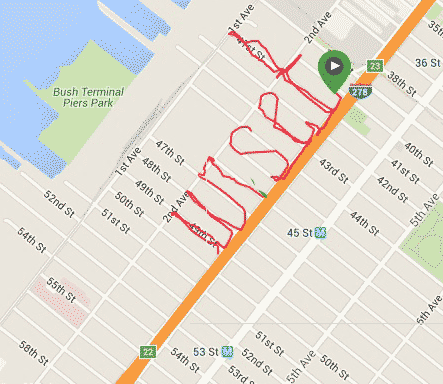
UNSET IN SUNSET PARK
Continuing my philosophy of "slow progress is better than no progress" today I resumed "writing" Sunset Park. I thought I only had enough time for two lowercase letters, so "un" it was, i.e. Sunset still needs the uppercase S. Below is the doctored image with "un" and "set" combined. There was a second green marker to denote the start of today's walk, but I don't like those things so I left it hidden in the lower layer. Only a trace of green shows in the combined image. The area was desolate and it was getting dark, the rain was coming down again, so it was good that I didn't attempt to complete Sunset. Any day now, any day now. We seem to go to Costco once a month so if I don't finish this in January, by February it will be done!

02 January 2016
HAPPY NEW YEAR - BROOKLYN RUN-MAPPING RETURNS
Happy New Year! I didn't declare it but deep down I know I want to resume blogging. There should be only so much Facebooking one can do. Be more of a content producer, not just a mere Liker and Bait-Clicker. Without much further ado, here's a topic close to my heart, running and spelling out the neighborhoods of Brooklyn! I prefer to call it Run-Mapping!
I should have known better but as I was done with the areas close to where I live, things get more challenging. I have this weird rule about running - no driving to the place to run. In other words, I should not drive x miles out to some place just to run around. I guess it has to do with my strong dislike of driving. If I am to complete this run-mapping of Brooklyn nabes, sooner or later I'll have to drive to where I want to run. Until such time, I'll make the most of my travel.
Late in December I ran to Marine Park just to spell "Park". Marine Park is about 5 km from me so spelling the whole "Marine Park" was not possible time-wise. Lately on these runs I have one or two phone apps to track my "writing". At one time I even thought if not for this run-map project, I probably can retire my Garmin GPS watch. The apps work the same way with regards to pause and resume, so I can use them to virtually cut through city blocks to make letters like K and R with their pesky diagonal lines. When they actually work as they are supposed to, that is. On the "Park" run, they didn't. Both Strava and MapMyFitness totally miss the P and then went crazy the rest of the run. Luckily, I did have the trusty Garmin, even though the lack of a rectangular city grid threw me off my course. As shown below, "Pa" is a big disappointment, even to a non-perfectionist like me. The "a" is too far away from its neighbors and "r" looks too much like an "n". I should have done my usual virtual trespassing in making the diagonal lines in "k". I use the picture in the map anyway but deep down I know I will re-run that route to make a better word.
Even though I am a member of the Prospect Park Track Club, I don't go to Prospect Park that much. Living far south almost in Coney Island, it's a bit of a trip for me. But I do go there from time to time and I should take advantage of those trips to finally add Park Slope and neighbors to my map.
On New Year's Day, I volunteered as a backup time-keeper for the Club's Harry Handicap race, held in Prospect Park. After the race, I had some food and was in no shape to run so I did the next best thing to spell out "Slope" - I walked. It was not as interesting as running but for these far-flung places I just have to make the best of my time. Again, MapMyFitness screwed up but Garmin Forerunner again saved the day. I gladly used the picture in the big map although there are many more street blocks I need to capture to make the map truly continuous.
Given the annoying changes Garmin make to its web site, I should hurry up and run more neighborhoods sooner before some changes render my techniques useless. Wish me luck!


18 October 2015
WELCOME TO BAY RIDGE ETC
Welcome to Bay Ridge and Dyker Heights, the two neighborhoods I recently added to my Brooklyn GPS map. The map really needs to be expanded to include other neighborhoods but work has kept me busy. I know, I know, Manhattan Beach still does not have its beach and Bath Beach should be further to the west. So many nabes, so little time.
I must note that Bay Ridge was somewhat challenging in that its east-west streets are wider than the north-south ones. I ended up using lots of iTrespassing to make the lowercase letters half-a-block wide. It was a decision I made while out running. In the planning stage, I was going to use the entire block's width, thus would not have enough width to spell Ridge, so I started the e in Dyker Heights and it unfortunately overlaps the D in Dyker. Another word to re-write some day perhaps...

I must note that Bay Ridge was somewhat challenging in that its east-west streets are wider than the north-south ones. I ended up using lots of iTrespassing to make the lowercase letters half-a-block wide. It was a decision I made while out running. In the planning stage, I was going to use the entire block's width, thus would not have enough width to spell Ridge, so I started the e in Dyker Heights and it unfortunately overlaps the D in Dyker. Another word to re-write some day perhaps...

30 August 2015
BEAST PACING
I love running and already explored different areas of the sports. I've run various distances from 5K to full marathon. I volunteered/worked as course marshal, lead cyclist, water station staff, bag-checker, photographer, etc. Something new I'm about to get into is pacing, that is, running a race at a specific pace holding a corresponding sign so that other runners of that pace can follow. Or pass me if they choose to. My first pacing race will be the Run and Ride Half Marathon at Dorney Park, http://www.runandriderace.com/#!dorneyparkhalf/c24p1 . The company that coordinate pacers and race organizers is Beast Pacing, http://beastpacing.com . I love encouraging runners so I really look forward to the race. I just hope they don't run with headphones so that my words of encouragement won't go to waste. I myself don't run with headphones whatsoever. Here's to Beast Pacing!
The images are made from two route arts, from my morning runs yesterday (Saturday Aug 29) and today (Sunday Aug 30), digitally combined.

The images are made from two route arts, from my morning runs yesterday (Saturday Aug 29) and today (Sunday Aug 30), digitally combined.

22 August 2015
A BEACH IN BROOKLYN
Having a job is nice but being at work 9 hours a day plus 2+ hours driving back and forth and you then don't have time for fun things, like running and tracing out words that represent the locale. Even with some new pairs of running shoes to test out I didn't add any new neighborhoods to my GPS Brooklyn map. I finally got around to putting on a new pair of Kismet Core Pop from Newton Running and made the "Manhttn" map below, for the neighborhood of "Manhattan Beach". I know, a few vowels are missing but I really did not have much width and height to work with. Hampton Avenue only runs so far east. While I can go as far as the gate of Brooklyn Community College, I wouldn't have the necessary two-avenue height to make the t's stand out. Using artistic license and dropping the a's is the way to go. Sorry, Manhattan.
For work, I drive by the area everyday, via the Belt Parkway, so one of these days I'll just stop by and spell the shorter version of Beach, namely "Bch". Yeah, I know the neighborhood border on the west is West End Avenue. In planning the route, I realized that if I stick to that, the second t would not have room to display its horizontal stroke. So invade Brighton Beach, at Corbin Place, I did.


For work, I drive by the area everyday, via the Belt Parkway, so one of these days I'll just stop by and spell the shorter version of Beach, namely "Bch". Yeah, I know the neighborhood border on the west is West End Avenue. In planning the route, I realized that if I stick to that, the second t would not have room to display its horizontal stroke. So invade Brighton Beach, at Corbin Place, I did.


25 July 2015
BRIGHTON BEACH MEMOIRS
After a two-hour car drive in yucky NYC traffic to go from the Coney Island area to the High Bridge Celebration, I felt pretty lousy. The festival was good but since I just visited the area a few weeks back for the High Bridge 5K Trail Race, it was not as big a novelty as it could be. The long car drive didn't help. I salvaged the day by completing my push to put Brighton Beach, Brooklyn on my map.
It was quite a challenge to add the Beach to the seaside town. There was not much vertical room to work so I had to use the beach area. In the beginning, I walked with my running shoes but after a while I decided to blend in by walking barefoot. As a bonus, I was able to walk right into the lapping waves, aaahhh. Note that not only I didn't have much vertical space to maneuver in, because of construction, the Boardwalk ends at Coney Island Avenue, where the h is. I spelled backward from the h and used MapMyRun's on-screen path to make sure I have enough space between the letters. Everything went well until B, which turned out to have too small a belly. Oh well, it's a busty B, or maybe it's just upside down.

Speaking of Brighton Beach memories, here is what used to be "my" first home in the U.S. This is the corner of Brighton 1 Street and Neptune Avenue. Neptune runs left to right whereas Brighton 1 is where the five cars point to. The road used to be one-way the other way. My first night in the U.S. was spent in a house that would be where where the white car (fourth in the line) is. Oh well, the price of commercialism. Maybe someday when I become rich and famous I can buy the new building to knock it back down and rebuild the old home from a photo my #1 Blog Fan has.

22 July 2015
WELCOME TO BRIGHTON BEACH, WELL, ALMOST
The past two days were hot and humid. I didn't get up early enough to beat the heat, i.e. run at 5 AM or so. Today I made up by running "Brighton", as in Brighton Beach. I didn't like the fact that the area is small, with few large rectangular blocks to work with. I thought of skipping it but then Eugene Morris Jerome may be upset. My first night in the U.S. some 30+ years ago, I did sleep in a house in the area. It belonged to an uncle but he has moved away since then. The new owner knocked down the house, along with a few adjacent ones, and a big building is being constructed on the lot.
I knew that the area has these mouthful Brighton 1 Street and 2 Street etc but did not know about all the alleys that in other parts of town would just remain nameless. There were Brighton 5 Walk, Brighton 5 Court, Brighton 1 Path, etc. Most of these so-called streets are narrow and are mere empty space between two houses. It is nice to have them nonetheless although I would not use them late at night.

I knew that the area has these mouthful Brighton 1 Street and 2 Street etc but did not know about all the alleys that in other parts of town would just remain nameless. There were Brighton 5 Walk, Brighton 5 Court, Brighton 1 Path, etc. Most of these so-called streets are narrow and are mere empty space between two houses. It is nice to have them nonetheless although I would not use them late at night.

 |
| T-intersection of Brighton 1 Path, which continues to the right of the tree, and Brighton 1 Walk, which runs from the foreground of the photo to the background. |
 |
| Brighton 5 Court, which simply connects Brighton 5 Street to Brighton 6 Street. It is relatively wide compared to other named alleys in the area. I recall one really narrow alley with overgrown weed and three or four guys sitting in the middle of the road. Mugger paradise! |
18 July 2015
WELCOME TO SHEEPSHEAD BAY!
My Brooklyn map-building continues to crawl forward, slowly. The latest three runs put Sheepshead Bay on the map, so to speak.


To round out the coastal towns, next I will have to do Brighton Beach, which is immediately to the east of Coney Island, and Manhattan Beach, right below Sheepshead. Both are tiny towns compared to Sheepshead Bay, with insufficient room to spell out the whole words. I'll have to compromise somehow.
08 July 2015
WELCOME TO CONEY ISLAND!
Welcome to Coney Island! Some time ago I ran the route for "Coney" but never got around to adding "Island", until this week. It is a good thing that I took advantage of the open space in Leon Kaiser Park to make most of "Coney" because the island (which is not really an island any more) is not "tall" enough to give me much room to work with. I thought of using the space between the Boardwalk and the beach but running on sand is no fun. I studied what was available and what I did with "Coney" and concluded that I could do it with Surf Avenue and the Boardwalk. Because of constructions, some streets no longer led to the Boardwalk but good thing I have that one trick in my bag. I just had to run back and forth over some streets, but technically I can cut through walls and other objects. For the I, I could have jumped off the Boardwalk and land on the sand below but to be safe I used my technique.
Onward to Sheepshead Bay!

Onward to Sheepshead Bay!

07 July 2015
WELCOME TO GRAVESEND AND BENSONHURST
Welcome to Gravesend and Bensonhurst! It took a few runs to have it done correctly but it is worthwhile. The second e in "send" is not perfect, but that will do. "Bensonhurst" was created from scratch, now a few blocks north of Bath Beach border. I probably will re-do Bath Beach to move it westward toward 14th Avenue and away from Gravesend.
The next neighborhoods I'll put on the map, so to speak, will probably be those to the east and south of Gravesend, just to round things out. Such as Coney Island and Sheepshead Bay. Afterward I'll march northward to connect to Prospect Park, since I have many friends living up there, they may appreciate it.

The next neighborhoods I'll put on the map, so to speak, will probably be those to the east and south of Gravesend, just to round things out. Such as Coney Island and Sheepshead Bay. Afterward I'll march northward to connect to Prospect Park, since I have many friends living up there, they may appreciate it.

12 June 2015
WELCOME TO BROOKLYN
So I did not win the Newton Running route art contest. Did not even get to be one of the three finalists having a shot at winning shoes for life plus a GPS watch. After a short time feeling unhappy about it, I decided to start a new, very ambitious project: create a map of all the Brooklyn neighborhoods through run art. It is ambitious indeed as I don't know all the neighborhoods. Sure I can start with my own area and adjacent ones, but the thought of driving elsewhere just to run a route sure is not appealing to me. The thing is once I am done, whenever that is, I'll know a lot more about Brooklyn.
I belong to a NextDoor.com neighborhood made for Bath Beach residents so the first nabe I ran was Bath Beach. I made two separate runs and stitched the two pieces together. I am not that happy with the B in Bath and may re-run the route one of these days. Next I thought I would cover my own turf and ran "Grave" for Gravesend. I did feel something odd when I started to create the V, sure enough once I got back I discovered that the "r" and the "a" are stuck together. It was good that I decided early on to make Gravesend in two separate runs. No point of putting a lot of time into a run only to find out that it's no good. These days I run in the evening any way and dinner seems to come too soon each time, that is I have time constraint.
Today I was supposed to re-run Grave but I happened to be near Bensonhurst so I made "Benson". While "Benson" itself came out perfect, I made it too close to the border of Bath Beach and Bensonhurst such that when stitched Bensonhurst to the bigger map, the letters overlaps, rats!
Here is the work-in-progress map, warts and all. Slowly and surely I will have the entire Brooklyn represented as route arts.

23 March 2015
NEWTON RUNNING SPELL CHALLENGE WEEK 1
Many of my Facebook friends tell me they love my GPS art, i.e. words etc spelled out when I run with my GPS watch. Naturally, when Newton Running announced its Run It, Feel It, Spell It Challenge, I have a keen interest in it. I perused the official announcement and read all the Newton Ambassadors' blogs. They all mention that there will be daily prizes, then weekly, for six weeks, resulting in a few semi-finalists, then finally some finalists will be selected, and one of them will win the ultimate prize of Newton shoes for life, plus a Timex GPS watch!
I kept re-reading the Rules for details on the daily prizes but found nothing. I wrote to a few bloggers and got no response. I also wrote directly to Newton Running but it was the weekend and no answer came about. In the mean time, I wanted to get a run in and was in the mood of celebrating my return to Brooklyn after four weeks of work in Denver. So I spelled out "Brooklyn" and thought I would have an extra shot at the daily prize.
I often wondered how others "write" their words and letters. Many people have very blocky art or thick lines, which I think are not attractive. I suspect they use smartphone apps instead of GPS watches so I gave MapMyRun a shot while also using my trusty, ahem, Garmin GPS watch. (I promise to use the Timex watch if I win it...) The two "Brooklyn" words are shown below, the top being from connect.garmin.com and the other from MapMyRun. I'd go with the GPS watch any day. On the smartphone, the MapMyRun picture looked even worse.
 |
| "Brooklyn" as generated by Garmin GPS watch. |
 |
| "Brooklyn" as made by MapMyRun smartphone app. Thick lines, blocky text, not pretty. |
Today I heard back from Newton Running that there is indeed no daily prizes. I re-read the Rules one more time and concluded that, hopefully, my "Brooklyn" piece will be voided and not considered for judging. I think I did a better job with "Boulder" anyway. I probably will re-run "Brooklyn" for Week 2, which spans Wednesday 25 March through the 31st. I'll make sure the k looks better this time, i.e. with a longer upward diagonal stroke so that it does not look like an h.
 |
| My first entry to the Newton Spell Challenge. |
Subscribe to:
Posts (Atom)