Showing posts with label New York. Show all posts
01 April 2020
NYS ON PAWS
Quarantine and loneliness can go together well. A few weeks ago Governor Cuomo of New York State stated that the State was to be on P.A.U.S.E., where the acronym translates to some contrived meaning that basically says only essential businesses can stay open. Shortly afterward the wordsmith in me thought of New York State on P.A.W.S. My contrived meaning is Pets Are Wovewy Sidekicks, where Wovewy = Lovely, just the way pet owners talk to their pets, kinda like baby talk. I wouldn't know since I never have a pet but I watch pet videos every now and then. My little joke/pun is actually behind the time. I thought the government would declare that everyone needs to have a pet. On their own, people already ran out to animal shelters and cleared out all dogs and cats etc. It's totally understandable.
A friend mentioned the lack of nipple rings but I'll them out for now.
20 September 2019
I'M WALKIN' HERE! I'M WALKIN' HERE!
And I sure walked a lot. New York City is a pedestrian paradise, in some ways. Yes, there are many rude, or even evil, car-drivers and then there are also many lawless cyclists ready to knock down pedestrians. In general, the great thing is one can walk almost everywhere. Or run, for that matter. I used to be an avid runner, got up early in the morning to run a few miles, wash off the dirt, then go to work. Then I started working at a job that required a car commute, a commute that would be so much worse if I didn't leave the house by a certain hour in the morning. That meant no more running in the morning before going to work. I was able to walk a lot, before work or after, or during lunch breaks. I still ran on the weekends, or during the week on those rare days when I finished work early.
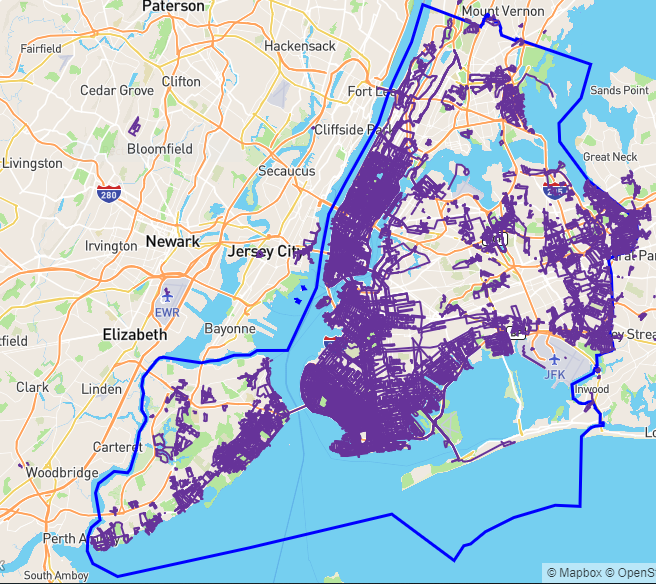
Wouldn't it be nice to visualize all that walking and running on one map? Yes, and that's exactly what the web site CityStrides offer. It is free to use, with some extra features if you pay for a subscription. There are a few subscription tiers, I think anyone with a job should be able to afford the fee, just to support the work of the one man who runs the whole thing.
Below is my map of New York City, i.e. the five boroughs (The Bronx, Manhattan, Brook, Queens, and Staten Island) combined. My activities only cover about 25% of the entire NYC so there is much work left to be done. There is no fame or fortune to claim, just bragging rights among friends or friendly competitors. A few people already covered the entire city, measured by some other means. The movie The World Before Your Feet chronicles one such feat. The guy in that movie didn't have a full-time job and achieved the goal in about six years. I have other obligations to satisfy so for now I am happy with my slow progress.
Wouldn't it be nice to visualize all that walking and running on one map? Yes, and that's exactly what the web site CityStrides offer. It is free to use, with some extra features if you pay for a subscription. There are a few subscription tiers, I think anyone with a job should be able to afford the fee, just to support the work of the one man who runs the whole thing.
Below is my map of New York City, i.e. the five boroughs (The Bronx, Manhattan, Brook, Queens, and Staten Island) combined. My activities only cover about 25% of the entire NYC so there is much work left to be done. There is no fame or fortune to claim, just bragging rights among friends or friendly competitors. A few people already covered the entire city, measured by some other means. The movie The World Before Your Feet chronicles one such feat. The guy in that movie didn't have a full-time job and achieved the goal in about six years. I have other obligations to satisfy so for now I am happy with my slow progress.
Labels:
Brooklyn,
CityStrides,
New York,
run,
walk
14 December 2012
BOO TO BIKE BAN ON BRIDGE!
I recently went out to the Rockaway to do some volunteer house-cleaning work. Muck-out is the term they use. The houses got flooded during the storm, especially the basement, everything is ruined and needs to be thrown out. It was sad to see boxes of stuff containing memories precious to the owners being tossed to the curb. Or a whole room with bookcases tipped over, content from the shelves spilled haphazardly all over the floor. For a pack rat like me, it was quite a horror.
One thing I love about running and cycling is to know the amount of time it takes to go to a specific place. I admire people who can look out at the horizon and roughly estimate the distance to a place. I have to personally travel over the distance with some measuring device, or measuring the distance afterward on a map. With my regular running, I now know how long it would take me to run to a certain point in my neighborhood. I am still relatively new to cycling and often wonder how long it would take to go to the Rockaway. Years ago I went as far as Breezy Point gate or some other street on the east side of the peninsula, but I don't remember now how long it took me, or how far the distance. For this week's trip, the distance from my home to Beach 129ish and the main road was about 16 km (10 miles). It took me about an hour and 15 minutes. I am happy to report that there was no sign on either approach to the Gil Hodge Memorial Bridge reminding cyclists to dismount and walk their bikes. Maybe the signs were knocked down by Hurricane Sandy and the government hasn't gotten around to re-erecting the new ones. All the times I used the bridge, only once did I see someone walking the bridge, I don't see the point of not letting cyclists ride on it. Supposedly in the summer fishermen use the bridge but then cyclists can just common sense to walk the bikes past these guys, no?
The trip back took a little longer, both because I strolled on Plum Beach's newly reclaimed beach and because of heavier traffic. Not long ago, beach erosion has encroached so much of Plum Beach, where the bike path enters the parking lot, that sandbags had to be placed to temporarily to hold back the water. A few weeks ago, before Hurricane Sandy, I noticed that the sand went much further out into the water. It's good to see that the beach was reclaimed but too bad the bike path is still under lots of sand. Perhaps that's one effect of Sandy, doh!
I headed home during the evening rush hours so once I got off the bike path near Knapp Street, there seemed to be no way of avoiding vehicular traffic. Emmons Avenue is bike-unfriendly, so was Avenues Z and Y. How I wish the Boardwalk is open to bike traffic outside of 5 AM to 10 AM.
One thing I love about running and cycling is to know the amount of time it takes to go to a specific place. I admire people who can look out at the horizon and roughly estimate the distance to a place. I have to personally travel over the distance with some measuring device, or measuring the distance afterward on a map. With my regular running, I now know how long it would take me to run to a certain point in my neighborhood. I am still relatively new to cycling and often wonder how long it would take to go to the Rockaway. Years ago I went as far as Breezy Point gate or some other street on the east side of the peninsula, but I don't remember now how long it took me, or how far the distance. For this week's trip, the distance from my home to Beach 129ish and the main road was about 16 km (10 miles). It took me about an hour and 15 minutes. I am happy to report that there was no sign on either approach to the Gil Hodge Memorial Bridge reminding cyclists to dismount and walk their bikes. Maybe the signs were knocked down by Hurricane Sandy and the government hasn't gotten around to re-erecting the new ones. All the times I used the bridge, only once did I see someone walking the bridge, I don't see the point of not letting cyclists ride on it. Supposedly in the summer fishermen use the bridge but then cyclists can just common sense to walk the bikes past these guys, no?
The trip back took a little longer, both because I strolled on Plum Beach's newly reclaimed beach and because of heavier traffic. Not long ago, beach erosion has encroached so much of Plum Beach, where the bike path enters the parking lot, that sandbags had to be placed to temporarily to hold back the water. A few weeks ago, before Hurricane Sandy, I noticed that the sand went much further out into the water. It's good to see that the beach was reclaimed but too bad the bike path is still under lots of sand. Perhaps that's one effect of Sandy, doh!
I headed home during the evening rush hours so once I got off the bike path near Knapp Street, there seemed to be no way of avoiding vehicular traffic. Emmons Avenue is bike-unfriendly, so was Avenues Z and Y. How I wish the Boardwalk is open to bike traffic outside of 5 AM to 10 AM.
![]() |
| Two things I like: large solar panel and my bicycle. |
![]() |
| Group photo, with the house owner, after a day of mucking. Who cares? New York Cares! |
![]() |
| Plum Beach with a few tons of sand recently dumped on it to reclaim the beach from erosion. Not that far ago, mere meters from the highway was where the water has approached. |
![]() |
| Sandbags to salvage the beach. |
Subscribe to:
Posts (Atom)


