Showing posts with label gwrite. Show all posts

27 January 2020

THAT'S AMORE

The past few years for Valentine's Day, I led a group run that spells out something related to that over-commercialized event.  The first year it was "LOVE", the following it was also "LOVE" but packed into a neat little square, in the style of that famous Robert Indiana sculpture.  Last year, it was "I {heart} U", where the heart symbol was where the {heart} is.  A Facebook memory reminded me, belatedly, that this year it should be "xoxo".  I said "belatedly" because I totally forgot about it and already designed the route to spell "amore", the Italian word for love.  It could have been the Spanish word "amor" but because of that Dean Martin song I went with "amore".  The little pun about "a moray" (eel) and "amore" is one of my favorites, so "amore" it is.

The route makes no use of any special skill with pausing and unpausing of GPS watch or smartphone app.  I am tempted to throw in one, though, to make the top of the "r" better show the arch at the top of that letter.  It'll be an optional thing.  If you don't do it, the letter still looks like an "r".

9:30 A.M. Saturday 15 February 2020
Bartel-Pritchard Square
Brooklyn, NY

We'll walk to the green dot on the "a", without activating watch or smartphone app, then start from there.  Event is open to the public, so do come if you are in the neighborhood.  I'll be on the traffic circle of Bartel-Pritchard a little before 9:30.


28 December 2017

THE YEAR IN GWRITING, PART TWO

In 2017, I actually won a contest with my run-art/gwriting/StravaArt, did some special requests from fans, and saw my work went to the dogs, in a good way, and, last but not least, created a menorah.

Just donut {swoosh}


Some time in August I found out from my track club's Facebook group that there was a donut-themed contest.  Draw anything donut-inspired for a chance to win a dozen donuts and entries into the Montclair Bread Company 5K Doughnut Run.  I actually came up with two designs, one of a donut being dunked into a cup plus the "Just donut {swoosh}" above.  Supposedly competition was light but I won that's all that matters.

Amy rules


In November, I asked for suggestions of what to write during future runs and one of the response was "Amy rules".  What's interesting with this particular task was that on that day I went for an NYRR OpenRun at Cunningham Park.  I planned to get there ahead of time to gwrite "Amy rules" before OpenRun started.  However, I made the mistake of trusting my memory, instead of Google Maps, and ended up getting lost briefly. Not totally lost, mind you, I still know my Queens geography, just enough to lose time and not able to finish the gwriting prior to OpenRun.  I used Strava app to do the writing so I simply paused it when I was done with "Amy".  Went to do OpenRun with Runkeeper app, then returned to where I was and un-paused Strava and proceeded to finish the whole two-word sentence.  Oh yes, it was no coincidence that I made "Amy rules" in the borough of Queens.

Bergie


Another suggestion came from the owner of a dog named Bergamot Grey, or Bergie for short.  Other dog names that I made in 2017 were Bandit and Beemer.  Just by coincidence that they all start with the letter B.  Yes, I am a dog person, but I do have a not-too-strict rule that dog names shouldn't be names normally reserved for people, such as Michael or Peter.

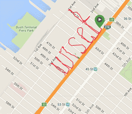
This Menorah Was Really Good


With the holiday season approaching, a Jewish friend asked if I could draw a dreidel.  Or a menorah.  Sure, I can.  New York City has many rectangular city blocks and a menorah with squarish branches could be drawn in many places.  But what if we want one that has nice, round branches?  As I reviewed the map for NYC, my first choice was the Mill Basin peninsula in Brooklyn.  However, unless I can walk on water (Jesus Christ!) or if Moses can part the water for me, there was no place draw the handle of the menorah.  A better choice was the crescent-shaped streets of Rego Park, Queens.  A few people were interested and we ended up having a small convoy of cars to make the trip from Prospect Park to Rego Park.  Shown above is my test run, during which I mistakenly lit the candles in the wrong spot.  I should know better that a few things in the Judaica world go from right to left, not unlike Chinese.  For the group run, we did it right to left but the flames didn't show that well.

27 December 2017

THE YEAR IN GWRITING

The first title I thought for this blog was “This Week In Gwriting”, which is a nod to Leo Laporte’s podcast "This Week In Tech". I didn’t get around to writing the blog post and the year 2017 is almost over, so without much further ado, let us review some of the Gwritings, or StravaArts, I made this soon-to-be-over year.


Linda


My most recent oeuvre, made just this Christmas Day.  It was not the first time I made a Linda route.  Back in August while vacationing in the exotic island of Aruba, one hot steamy morning I ran Linda but the non-grid streets threw me off.  It took a while before I found the chance to redo it, on the streets of un-exotic Brooklyn, New York.  While I can easily cut through a city block to make the middle section of the letter "a", I try to avoid relying on the trick.  While planning the run, I picked Flatlands Avenue as the street that will naturally provide the needed line.


Grab A Bite With Jimmy


"Grab A Bite With Jimmy" is another run-art that makes good use of the existing environment, i.e. no Dark Magic via the use of GPS app's pause function.  Well, to a certain extent.  Jimmy is this friend of mine who seems to have a very healthy appetite.  The quasi-roundabout near Zucker-Hillside Hospital provided the perfect round-ish food that Jimmy seems to eat a lot of.  However, to achieve the bite mark I did have to use Dark Magic.  While I have no plan of drawing offensive pictures any time soon, this was my early foray into drawing, not just writing.

Make Some Noises With Adam


I followed the success of "Grab A Bite With Jimmy" by making "Make Some Noises With Adam".  Adam won two awards earlier in the year from the track club.  Instead of wooden plaques or paper certificates, the prizes were cowbells.  Very useful for a cheerleader like Adam!  To get the trapezoidal shape of the cowbell I did have to resort to my special trick to make the slanting lines.

Resist With Lisa, Sort Of


Back in February, I made "resist" and dedicated to Lisa LMK and others who, duh, resist the current administration.  In November I wanted to make the both the fist and the word "Lisa" but I ran out of time.  Yes, these things take time.  Sorry, Lisa LMK!  I still have the area where "Lisa" would be, I'll return to the area some day to do it.  "Lisa" and fist will appear together in CityStrides, that web site that gives me so much joy and aggregation aggravation.

There are more but there are a few more days left of the old year.  I might make another post just yet!

18 July 2017

RUN ART GETTING MORE GRAPHIC

I'm pretty good at spelling out letters and words during my runs, as seen in "Crystal" and "Heather" below, some recent samples.


Naturally, my friends asked if I ever drew actual pictures, not just letters and numbers.  While I did a few, the majority of my run arts have been limited to just letters and numbers.  With my special block-cutting technique, technically anything can be drawn, given enough time and proper planning.  And so I did, recently, advance to the next phase of my run art, with "Jimmy" and "Adam". 


With the "Jimmy" piece, there is this roundabout traffic circle in Glen Oaks, Queens that I have yet covered on my CityStrides map. I have this friend Jimmy who is well-known for his strong appetite. The roundabout made a perfect food item, whether a bagel or a donut.  The fun got better as I tried to include a bite mark in the food item.  Of course, I had to use my virtual trespassing technique to make the bite mark.

Adam is another friend in the run community.  A great runner himself, he loves to cheer fellow runners with his cowbells.  Not just the small cowbells somewhat cube-ish type, but the real, rectangular ones.  Every year, Prospect Park Track Club has a dinner party at which members receive awards as voted by the club.    In past years, the awards came in the form of a plaque or similar form.  In 2016, someone came up with the excellent idea of awarding cowbells!  So useful!  Adam won in two categories and now often carry them to the cheer zone, thus in my run art there's a cowbell after his name.  To achieve the angular shape of the cowbell, I again resorted to cutting through city blocks.

14 March 2017

PROSPECT PARK SESQUICENTENNIAL

Prospect Park in Brooklyn opened to the public in 1867.  It is turning 150 years old this year.  The Prospect Park Alliance is hosting many events starting Saturday April 1.  On April 2, my running club, the Prospect Park Track Club, will host a run in cooperation with the Alliance.  I designed a route that spells out "150".  Faster runners will lead the group from the front while slowpokes like me will lead from the back.  The run starts at 9 A.M. and will be slightly less than 3 miles.

PPTC runs normally start from Grand Army Plaza but this run is different and will meet at 10th Street and Seventh Avenue, which is the top of the "1" in "150".  Actually, it will be slightly away from that corner, toward the park.  Usually when runners spell words and numbers they make very blocky and straight characters.  I go through great length to make sure the characters are curvy, that corners are rounded and not at ninety degrees.  It is easy to mistakenly spell "ISO" instead of "150" so I want to avoid that.  More details will be provided on how that's done.

Register at https://goo.gl/UknXdS

For more information about anniversary events hosted by the Prospect Park Alliance, visit

https://www.prospectpark.org/news-events/events/2017/4/2#opening-weekend-2017

25 November 2016

CITYSTRIDES - WHAT MORE CAN A MAP-LOVER ASK FOR?

I love maps.  I sometimes spell words during my runs.  I started to spell the many Brooklyn neighborhoods but life got in the way.  At some point, I thought about how nice it would be to have all my runs/walks on one map.  Turns out there is such a tool and it's called CityStrides.  You connect your CityStrides account to Strava, MapMyRun, and Runkeeper then all your routes are in one map!  So wonderful!  Of course, in my case many of my carefully drawn routes are no longer recognizable because the many lines overlap but it's still a nice way to visualize one's activities.  I love the tool so much I actually update this blog after a multi-month hiatus!!!


10 April 2016

MARINE PARK IS ON THE MAP

I have good news and bad news.  Good news is I am still on this ambitious project of "mapping" every Brooklyn neighborhood by running and spelling their names, in that neighborhood.  Or somewhere close.  Just this weekend I finally completed "Marine Park".  The bad news is I took too long to do this Garmin web site finally got rid of Classic view so now any additional maps will look slightly different.  "Marine Park" is one such.  The lines are darker, which is fine, but luckily the underlying map is still the same.  Whew.  All the more reason I should hurry up and finish this before any more changes, whether with Garmin.com or with my own health.  You never know, one day you can be healthy and all, the next day you can no longer run.

For "Marine Park", I broke one of my rules about running.  I hate driving and when I go for a run, I absolutely don't want to drive somewhere just to run there.  But I have to be realistic now.  While I can certainly drive to Marine Park to do the run, it is just much faster when I drive.  And there is plenty of parking at the park, so I really have no excuse not to.  With this executive decision made, I plan to drive to Prospect Park etc some weekend day, really early in the morning for a better chance of finding a parking spot, and be done with those faraway places.  Let's hope the map will be filled soon!


10 January 2016

UNSET IN SUNSET PARK

Continuing my philosophy of "slow progress is better than no progress" today I resumed "writing" Sunset Park.  I thought I only had enough time for two lowercase letters, so "un" it was, i.e. Sunset still needs the uppercase S.  Below is the doctored image with "un" and "set" combined.  There was a second green marker to denote the start of today's walk, but I don't like those things so I left it hidden in the lower layer.  Only a trace of green shows in the combined image.  The area was desolate and it was getting dark, the rain was coming down again, so it was good that I didn't attempt to complete Sunset.  Any day now, any day now.  We seem to go to Costco once a month so if I don't finish this in January, by February it will be done!


03 January 2016

SET IN SUNSET PARK

What a great feeling it is once you are resolved to do something and make modifications to your plan to achieve the final outcome.  So I decided I would walk if I have to, instead of running, just to complete my run-mapping of Brooklyn.  Running is more interesting but not always optimal, like after a meal.  Just a few days ago I churned out "Slope", for Park Slope, after a brunch with the track club.  Today I was in the neighborhood of Sunset Park and had a little time for running.  Not enough to do the entire "Sunset Park", or even the word "Sunset", but that is not a problem.  I am already stitching together the map in Photoshop, no harm to do one syllable at a time, like "set" as in "Sunset".  "t" didn't come out a straight as it should but it's beyond my control.  I guess at different time of day the satellite can be uncooperative.  Perhaps when I stitch "set" together with the other syllables it won't look so bad.


02 January 2016

HAPPY NEW YEAR - BROOKLYN RUN-MAPPING RETURNS

Happy New Year!  I didn't declare it but deep down I know I want to resume blogging.  There should be only so much Facebooking one can do.  Be more of a content producer, not just a mere Liker and Bait-Clicker.  Without much further ado, here's a topic close to my heart, running and spelling out the neighborhoods of Brooklyn!  I prefer to call it Run-Mapping!

I should have known better but as I was done with the areas close to where I live, things get more challenging.  I have this weird rule about running - no driving to the place to run.  In other words, I should not drive x miles out to some place just to run around.  I guess it has to do with my strong dislike of driving.  If I am to complete this run-mapping of Brooklyn nabes, sooner or later I'll have to drive to where I want to run.  Until such time, I'll make the most of my travel.

Late in December I ran to Marine Park just to spell "Park".  Marine Park is about 5 km from me so spelling the whole "Marine Park" was not possible time-wise.  Lately on these runs I have one or two phone apps to track my "writing".  At one time I even thought if not for this run-map project, I probably can retire my Garmin GPS watch.  The apps work the same way with regards to pause and resume, so I can use them to virtually cut through city blocks to make letters like K and R with their pesky diagonal lines.  When they actually work as they are supposed to, that is.  On the "Park" run, they didn't.  Both Strava and MapMyFitness totally miss the P and then went crazy the rest of the run.  Luckily, I did have the trusty Garmin, even though the lack of a rectangular city grid threw me off my course.  As shown below, "Pa" is a big disappointment, even to a non-perfectionist like me.  The "a" is too far away from its neighbors and "r" looks too much like an "n".  I should have done my usual virtual trespassing in making the diagonal lines in "k".  I use the picture in the map anyway but deep down I know I will re-run that route to make a better word.

Even though I am a member of the Prospect Park Track Club, I don't go to Prospect Park that much.  Living far south almost in Coney Island, it's a bit of a trip for me.  But I do go there from time to time and I should take advantage of those trips to finally add Park Slope and neighbors to my map.

On New Year's Day, I volunteered as a backup time-keeper for the Club's Harry Handicap race, held in Prospect Park.  After the race, I had some food and was in no shape to run so I did the next best thing to spell out "Slope" - I walked.  It was not as interesting as running but for these far-flung places I just have to make the best of my time.  Again, MapMyFitness screwed up but Garmin Forerunner again saved the day.  I gladly used the picture in the big map although there are many more street blocks I need to capture to make the map truly continuous.

Given the annoying changes Garmin make to its web site, I should hurry up and run more neighborhoods sooner before some changes render my techniques useless.  Wish me luck! 


18 October 2015

WELCOME TO BAY RIDGE ETC

Welcome to Bay Ridge and Dyker Heights, the two neighborhoods I recently added to my Brooklyn GPS map.  The map really needs to be expanded to include other neighborhoods but work has kept me busy.  I know, I know, Manhattan Beach still does not have its beach and Bath Beach should be further to the west.  So many nabes, so little time.

I must note that Bay Ridge was somewhat challenging in that its east-west streets are wider than the north-south ones.  I ended up using lots of iTrespassing to make the lowercase letters half-a-block wide.  It was a decision I made while out running.  In the planning stage, I was going to use the entire block's width, thus would not have enough width to spell Ridge, so I started the e in Dyker Heights and it unfortunately overlaps the D in Dyker.  Another word to re-write some day perhaps...


30 August 2015

BEAST PACING

I love running and already explored different areas of the sports.  I've run various distances from 5K to full marathon.  I volunteered/worked as course marshal, lead cyclist, water station staff, bag-checker, photographer, etc.  Something new I'm about to get into is pacing, that is, running a race at a specific pace holding a corresponding sign so that other runners of that pace can follow.  Or pass me if they choose to.  My first pacing race will be the Run and Ride Half Marathon at Dorney Park, http://www.runandriderace.com/#!dorneyparkhalf/c24p1 .  The company that coordinate pacers and race organizers is Beast Pacing, http://beastpacing.com .  I love encouraging runners so I really look forward to the race.  I just hope they don't run with headphones so that my words of encouragement won't go to waste.  I myself don't run with headphones whatsoever.  Here's to Beast Pacing!

The images are made from two route arts, from my morning runs yesterday (Saturday Aug 29) and today (Sunday Aug 30), digitally combined.


22 August 2015

A BEACH IN BROOKLYN

Having a job is nice but being at work 9 hours a day plus 2+ hours driving back and forth and you then don't have time for fun things, like running and tracing out words that represent the locale.  Even with some new pairs of running shoes to test out I didn't add any new neighborhoods to my GPS Brooklyn map.  I finally got around to putting on a new pair of Kismet Core Pop from Newton Running and made the "Manhttn" map below, for the neighborhood of "Manhattan Beach".  I know, a few vowels are missing but I really did not have much width and height to work with.  Hampton Avenue only runs so far east.  While I can go as far as the gate of Brooklyn Community College, I wouldn't have the necessary two-avenue height to make the t's stand out.  Using artistic license and dropping the a's is the way to go.  Sorry, Manhattan.

For work, I drive by the area everyday, via the Belt Parkway, so one of these days I'll just stop by and spell the shorter version of Beach, namely "Bch".  Yeah, I know the neighborhood border on the west is West End Avenue.  In planning the route, I realized that if I stick to that, the second t would not have room to display its horizontal stroke.  So invade Brighton Beach, at Corbin Place, I did.


25 July 2015

BRIGHTON BEACH MEMOIRS

After a two-hour car drive in yucky NYC traffic to go from the Coney Island area to the High Bridge Celebration, I felt pretty lousy.  The festival was good but since I just visited the area a few weeks back for the High Bridge 5K Trail Race, it was not as big a novelty as it could be.  The long car drive didn't help.  I salvaged the day by completing my push to put Brighton Beach, Brooklyn on my map.

It was quite a challenge to add the Beach to the seaside town.  There was not much vertical room to work so I had to use the beach area.  In the beginning, I walked with my running shoes but after a while I decided to blend in by walking barefoot.  As a bonus, I was able to walk right into the lapping waves, aaahhh.  Note that not only I didn't have much vertical space to maneuver in, because of construction, the Boardwalk ends at Coney Island Avenue, where the h is.  I spelled backward from the h and used MapMyRun's on-screen path to make sure I have enough space between the letters. Everything went well until B, which turned out to have too small a belly.  Oh well, it's a busty B, or maybe it's just upside down.


Speaking of Brighton Beach memories, here is what used to be "my" first home in the U.S.  This is the corner of Brighton 1 Street and Neptune Avenue.  Neptune runs left to right whereas Brighton 1 is where the five cars point to.  The road used to be one-way the other way.  My first night in the U.S. was spent in a house that would be where where the white car (fourth in the line) is.  Oh well, the price of commercialism.  Maybe someday when I become rich and famous I can buy the new building to knock it back down and rebuild the old home from a photo my #1 Blog Fan has.


22 July 2015

WELCOME TO BRIGHTON BEACH, WELL, ALMOST

The past two days were hot and humid.  I didn't get up early enough to beat the heat, i.e. run at 5 AM or so.  Today I made up by running "Brighton", as in Brighton Beach.  I didn't like the fact that the area is small, with few large rectangular blocks to work with.  I thought of skipping it but then Eugene Morris Jerome may be upset.  My first night in the U.S. some 30+ years ago, I did sleep in a house in the area.  It belonged to an uncle but he has moved away since then.  The new owner knocked down the house, along with a few adjacent ones, and a big building is being constructed on the lot.

I knew that the area has these mouthful Brighton 1 Street and 2 Street etc but did not know about all the alleys that in other parts of town would just remain nameless.  There were Brighton 5 Walk, Brighton 5 Court, Brighton 1 Path, etc.  Most of these so-called streets are narrow and are mere empty space between two houses.  It is nice to have them nonetheless although I would not use them late at night.


T-intersection of Brighton 1 Path, which continues to the right of the tree, and Brighton 1 Walk, which runs from the foreground of the photo to the background.

Brighton 5 Court, which simply connects Brighton 5 Street to Brighton 6 Street.  It is relatively wide compared to other  named alleys in the area.  I recall one really narrow alley with overgrown weed and three or four guys sitting in the middle of the road.  Mugger paradise!


18 July 2015

WELCOME TO SHEEPSHEAD BAY!

My Brooklyn map-building continues to crawl forward, slowly.  The latest three runs put Sheepshead Bay on the map, so to speak.


To round out the coastal towns, next I will have to do Brighton Beach, which is immediately to the east of Coney Island, and Manhattan Beach, right below Sheepshead.   Both are tiny towns compared to Sheepshead Bay, with insufficient room to spell out the whole words.  I'll have to compromise somehow.

08 July 2015

WELCOME TO CONEY ISLAND!

Welcome to Coney Island!  Some time ago I ran the route for "Coney" but never got around to adding "Island", until this week.  It is a good thing that I took advantage of the open space in Leon Kaiser Park to make most of "Coney" because the island (which is not really an island any more) is not "tall" enough to give me much room to work with.  I thought of using the space between the Boardwalk and the beach but running on sand is no fun.  I studied what was available and what I did with "Coney" and concluded that I could do it with Surf Avenue and the Boardwalk.  Because of constructions, some streets no longer led to the Boardwalk but good thing I have that one trick in my bag.  I just had to run back and forth over some streets, but technically I can cut through walls and other objects.  For the I, I could have jumped off the Boardwalk and land on the sand below but to be safe I used my technique.

Onward to Sheepshead Bay!


12 June 2015

WELCOME TO BROOKLYN

So I did not win the Newton Running route art contest.  Did not even get to be one of the three finalists having a shot at winning shoes for life plus a GPS watch.  After a short time feeling unhappy about it, I decided to start a new, very ambitious project: create a map of all the Brooklyn neighborhoods through run art.  It is ambitious indeed as I don't know all the neighborhoods.  Sure I can start with my own area and adjacent ones, but the thought of driving elsewhere just to run a route sure is not appealing to me.  The thing is once I am done, whenever that is, I'll know a lot more about Brooklyn.

I belong to a NextDoor.com neighborhood made for Bath Beach residents so the first nabe I ran was Bath Beach.  I made two separate runs and stitched the two pieces together.  I am not that happy with the B in Bath and may re-run the route one of these days.  Next I thought I would cover my own turf and ran "Grave"  for Gravesend.  I did feel something odd when I started to create the V, sure enough once I got back I discovered that the "r" and the "a" are stuck together.  It was good that I decided early on to make Gravesend in two separate runs.  No point of putting a lot of time into a run only to find out that it's no good.  These days I run in the evening any way and dinner seems to come too soon each time, that is I have time constraint.

Today I was supposed to re-run Grave but I happened to be near Bensonhurst so I made "Benson".  While "Benson" itself came out perfect, I made it too close to the border of Bath Beach and Bensonhurst such that when stitched Bensonhurst to the bigger map, the letters overlaps, rats!

Here is the work-in-progress map, warts and all.  Slowly and surely I will have the entire Brooklyn represented as route arts.


30 April 2015

NEWTON RUNNING SPELLIT CHALLENGE - THE FINAL WEEK

Time sure flies when you have fun!  A few weeks ago Newton Running started accepting entries for its route art / GPS art contest, http://www.newtonrunning.com/feel-newton/run-feel-spell-challenge.  I did not win anything until the third week, then again the fourth week, and one more during the fifth week.  Unfortunately, it was "Always the bridesmaid, not the bride".  The semi-final weekly prize package, consisting of visor, water bottle, and socks is nice but of course the combo of a Timex GPS watch and a pair of running shoes is way better.  Infinitely better would be the Grand Prize of Newton Shoes For Life!

The weekly contest ended at end-of-day on Tuesdays and I got notified on Thursdays via Twitter.  (In the beginning, I posted to Instagram but I started to hate its square requirement.  My route art usually spreads out horizontally, in order for the whole thing to be seen in Instagram I would have to shrink it to fit into the square frame, very annoying.)  The three winning entries are "relaxed", "reflective" (or rather the mirror image of that), and "tough", shown below.

I made "complete" this past Monday, plenty of time to make the Tuesday EOD deadline.  Supposedly between Wednesday the 29th of April and Friday the first of May the public gets to vote on the Grand Prize winner.  However, I haven't seen any announcement in Twitter yet.  (Don't ask me about searching for info on Instagram from a desk computer!  I can't stand Instagram!)  No winners announced this week, no link for the public to vote on the three Finalists.  I suppose the contest judges have day jobs to attend to.  It cannot hurt to have a little hope that maybe judging is not done yet, for Week #6, and that my "complete" art will finally be selected as a Weekly Finalist.  Maybe the public voting phase is already extended and that I will be selected among the three Finalists.  There's nothing to do but wait and see.

I opened the floodgate on creativity for this word, virtually trespassing private properties with my nifty pause-unpause technique to make letters like X.  I could have made "a" differently but I chose to flex my creative muscle.

Despite the narrow "f", I still like this route the most.  Mirror image, how about that?!  The first time I tried to write this I only had time to spell "lective".  I also cut corners and made some letters shorter so the whole word didn't look nice.  I tried again the next day and the result is much better.

I made good use of the locale's physical features, the "h" sticking above the other letters into what was once the mainland, from Coney Island's perspective.  My tweet said that "running makes me feel tough".  Coincidentally, the neighborhood I ran in was tough-looking, with metal bars on windows in most of the houses.


Running does make me feel complete.  I would feel even more complete if I win shoes for life.  BTW, I find that when it comes to legible GPS art, serifs are your friends.

25 March 2015

NEWTON RUNNING CHALLENGE, NOT!

Yesterday was the last day of Week 1 of the Newton Running Run It Feel It Spell It Challenge.  I already got my entry done and was itching to run.  I recall that Charity Miles, the org behind the app of the same name, is on a quest to get the big cola company, Coca-Cola, to sign on as a sponsor.  For those who don't know, Charity Miles app allows runners etc to raise funds for charities as they go about doing what they love, be it running, cycling, walking etc.  In the beginning I had issues with the app but it has improved much since then.  I met the app's founder, Gene Gurkoff, a few times and he's one cool guy.  I use the app regularly and more than once help promote it in person or through my GPS art.  Fresh off my latest work project (read: unemployed) this week, I had a little time in the evening to help Gene with his push for Coca-Cola to become a sponsor.

The first screen below is the usual GPS art made with my Garmin Forerunner 210.  Note that I live near the letter "L" and since I wanted to start "writing" and running ASAP, I "wrote" the phrase backward, starting with the second "a" going from east to west.  It took about 1.5 hours to traverse the 8.37-km course.  I made a booboo with the leftmost "C", the curve should come down into Bay 28th Street but I was at the end of the run and was not thinking straight.  I always do these runs from memory, with occasional checking of the map on my smartphone, never with a piece of paper in hand or the course already marked.  Maybe I should, to avoid these little mistakes.

CocaCola as made by GPS watch Garmin Forerunner 210.

While checking out other entries in the Newton Running Spell Challenge, I noticed the ghostly writings in some of them.  I am not too fond of them but curious what app was used.  I already experimented with MapMyRun and yesterday I checked out Runtastic.  That was it, and the result is shown below.

Runtastic map with speed info and mile markers.

Runtastic maps do not have to be shown that way.  It's just the default view.  I played around with the map via a web browser on a real computer, i.e. not on a smartphone or the like, and was able to show just the path itself.  No elevation, no speed, no markers.  The route even shows in red, like Coca-Cola's color!

I hope Gene and Charity Miles will get the Coca-Cola sponsorship!

Runtastic map without extraneous info.