31 March 2015

NEWTON RUNNING SPELL CHALLENGE WEEK 2, AND MORE

Today marks the end of Week 2 of the Run It Feel It Spell It Challenge sponsored by Newton Running.  I didn't make the cut for the first week and we'll have to wait a few days to see if my entry below is any good.


My accompanying text is

HOT, b/c I sweat easily, but, ladies, feel free to think "hot-looking"

Nowhere does the contest rule says there will be points for humor but I couldn't help it. The rule does say

1) creativity and composition of word(s) and caption (33%), 2) originality of word(s) (33%), and 3) ability of word(s) and caption to portray how running makes you feel (34%) (the “Judging Criteria”).

Criteria #1 is easy to understand, #2 is kinda tricky, as there are only so many adjectives you can describe the feeling associated with running.  Truly feeling it, and the word should not be crazy long that one would have to run marathon distance to make it.  Criteria #3 is even harder to interpret, I guess it's all in the way you write your caption, with Twitter's 140-character limit and all.  Instagram can be used also but I hate its square limitation.  My GPS arts are usually rectangular-shaped, i.e. two distinct dimensions and not all four sizes are equal, so to satisfy Instagram I would have to do some extra work.

One day, instead of worrying about these restrictions of the Spell Challenge, I went out for a run with something else in mind to spell.  Johnson & Johnson is a great sponsor of Charity Miles, which I in turn am a great supporter.  While I can technically run whatever distance needed to spell out Johnson & Johnson, I decided to take advantage of the repeated name and only ran Johnson.


I took care to include the plus sign under Johnson.  I know, it is not much of a plus sign but my restrain with GPS art is everything has to be connected.  At the moment I did not consider running up and down East 3rd Street instead of making the loop.


Johnson & Johnson, after a few minutes in Photoshop.  Since Ocean Parkway is already highlighted on the map, I artificially lined it up when I stitched the original picture and its clone.  I carefully cropped out the plus sign in the lower picture.  Could be better, but good enough for illustration purpose.

25 March 2015

NEWTON RUNNING CHALLENGE, NOT!

Yesterday was the last day of Week 1 of the Newton Running Run It Feel It Spell It Challenge.  I already got my entry done and was itching to run.  I recall that Charity Miles, the org behind the app of the same name, is on a quest to get the big cola company, Coca-Cola, to sign on as a sponsor.  For those who don't know, Charity Miles app allows runners etc to raise funds for charities as they go about doing what they love, be it running, cycling, walking etc.  In the beginning I had issues with the app but it has improved much since then.  I met the app's founder, Gene Gurkoff, a few times and he's one cool guy.  I use the app regularly and more than once help promote it in person or through my GPS art.  Fresh off my latest work project (read: unemployed) this week, I had a little time in the evening to help Gene with his push for Coca-Cola to become a sponsor.

The first screen below is the usual GPS art made with my Garmin Forerunner 210.  Note that I live near the letter "L" and since I wanted to start "writing" and running ASAP, I "wrote" the phrase backward, starting with the second "a" going from east to west.  It took about 1.5 hours to traverse the 8.37-km course.  I made a booboo with the leftmost "C", the curve should come down into Bay 28th Street but I was at the end of the run and was not thinking straight.  I always do these runs from memory, with occasional checking of the map on my smartphone, never with a piece of paper in hand or the course already marked.  Maybe I should, to avoid these little mistakes.

CocaCola as made by GPS watch Garmin Forerunner 210.

While checking out other entries in the Newton Running Spell Challenge, I noticed the ghostly writings in some of them.  I am not too fond of them but curious what app was used.  I already experimented with MapMyRun and yesterday I checked out Runtastic.  That was it, and the result is shown below.

Runtastic map with speed info and mile markers.

Runtastic maps do not have to be shown that way.  It's just the default view.  I played around with the map via a web browser on a real computer, i.e. not on a smartphone or the like, and was able to show just the path itself.  No elevation, no speed, no markers.  The route even shows in red, like Coca-Cola's color!

I hope Gene and Charity Miles will get the Coca-Cola sponsorship!

Runtastic map without extraneous info.

23 March 2015

NEWTON RUNNING SPELL CHALLENGE WEEK 1

Many of my Facebook friends tell me they love my GPS art, i.e. words etc spelled out when I run with my GPS watch.  Naturally, when Newton Running announced its Run It, Feel It, Spell It Challenge, I have a keen interest in it.  I perused the official announcement and read all the Newton Ambassadors' blogs.  They all mention that there will be daily prizes, then weekly, for six weeks, resulting in a few semi-finalists, then finally some finalists will be selected, and one of them will win the ultimate prize of Newton shoes for life, plus a Timex GPS watch!

I kept re-reading the Rules for details on the daily prizes but found nothing.  I wrote to a few bloggers and got no response.  I also wrote directly to Newton Running but it was the weekend and no answer came about.  In the mean time, I wanted to get a run in and was in the mood of celebrating my return to Brooklyn after four weeks of work in Denver.  So I spelled out "Brooklyn" and thought I would have an extra shot at the daily prize.

I often wondered how others "write" their words and letters.  Many people have very blocky art or thick lines, which I think are not attractive.  I suspect they use smartphone apps instead of GPS watches so I gave MapMyRun a shot while also using my trusty, ahem, Garmin GPS watch.  (I promise to use the Timex watch if I win it...)  The two "Brooklyn" words are shown below, the top being from connect.garmin.com and the other from MapMyRun.  I'd go with the GPS watch any day.  On the smartphone, the MapMyRun picture looked even worse.


"Brooklyn" as generated by Garmin GPS watch.

"Brooklyn" as made by MapMyRun smartphone app.  Thick lines, blocky text, not pretty.

Today I heard back from Newton Running that there is indeed no daily prizes.  I re-read the Rules one more time and concluded that, hopefully, my "Brooklyn" piece will be voided and not considered for judging.  I think I did a better job with "Boulder" anyway.  I probably will re-run "Brooklyn" for Week 2, which spans Wednesday 25 March through the 31st.  I'll make sure the k looks better this time, i.e. with a longer upward diagonal stroke so that it does not look like an h.

My first entry to the Newton Spell Challenge.

20 March 2015

NEWTON RUNNING'S RUN IT, FEEL IT, SPELL IT CHALLENGE!

All good things must come to an end.  Almost four weeks ago I started my long visit, for business purpose, to Denver.  Now there is just a few hours of the work day then Saturday morning I'll fly back to the East Coast.

I enjoyed meeting a Facebook friend and a relative who I haven't seen some twenty years, and had time for some activities outside of work.  First weekend I ran a half-marathon, the That Dam Run race in Cherry Creek State Park, the second weekend I spent back in NYC, then the third weekend I volunteered for the Running of the Green 7K, organized by Volunteers of America.  I also did touristy things like touring the Coors Brewery, climbing a mesa, and visiting the art museum, the State Capitol, and the zoo.
 
Almost every day I rode the bike to work and back.  The first time I used a Bcycle did not end well, as the dock that I returned the bike malfunctioned.  Luckily someone fixed it and afterward I made sure the returned bike chirped three times to acknowledge that the return was successful.  One time a station didn’t release any bike at all but otherwise I did not have any problems with the bike-share system.  Bikes were always available and so were open docks at the stations.  Maybe not enough people are using the bikes or their system of moving bikes around was really effective.

It took me a few tries to find the best bike route between the hotel (Broadway and 6th Ave) and the office (Broadway and 16th Ave).  I knew better to avoid the busy roads like Broadway but then I made the mistake of thinking Cherry Creek Trail was the best way for me.  While the Trail is car-free, it runs below grade and has entrances/exits only every few blocks.  What’s more, once you are out of Downtown center, there are fewer bike stations.  The Trail exit nearest to the hotel requires a few blocks of walking to get to the nearest bike station.  In the end, it was Bannock Street that became my bike route.  I would start the bike trip from Denver Health, where the station is somewhat hidden from public view.  I am still used to New York City’s CitiBike docks that are mostly on public sidewalks, sometimes ever on the street.  Just a short ride with motorists and I would be mostly by myself on Bannock.  In the beginning, I returned the bike at the Webb Building station but by chance I discovered that there are bike lanes on the sidewalk between that station and the one at Denver Post, a block further north.  There are also bike lanes on the sidewalk of Civic Center Park, which would come in handy as one time I actually made the big loop around it, riding on Lincoln Street.


From my experience, Denver motorists are relatively nice people.  I always keep my bike out of their way but there were times I had no choice but to ride in front of them and slowed traffic down.  No one ever honked at me.  If they made rude gestures behind me I would not know.  Overall as I traveled in the city for work or pleasure I don’t recall hearing angry car horns or open hostility.

After the first week the weather improved greatly.  A few evenings I ran outdoor, sometimes along the Cherry Creek Trail, other times on random street route just to stay close to 
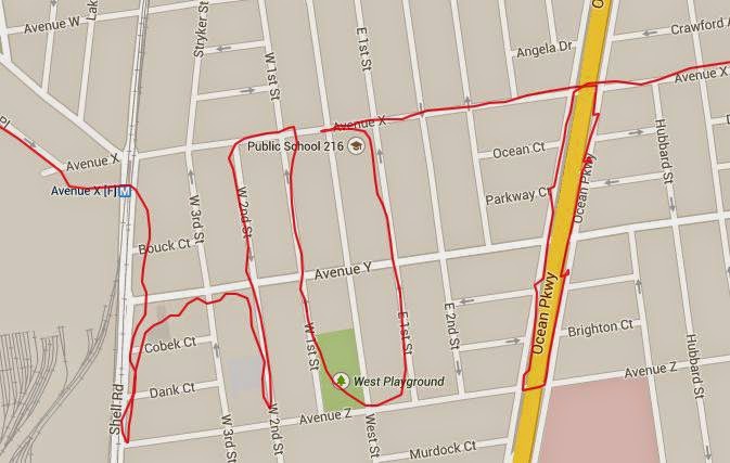
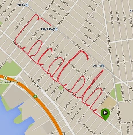
the hotel.  For my last run in Denver, I made a GPS art as my entry to Newton Running’s Run It, Feel It, Spell It Challenge.  Details of the challenge can be found at


http://www.newtonrunning.com/run-feel-spell-official-rules


My entry for the first week of the multi-week challenge is BOULDER.  The theme of the contest is "Running Makes Me Feel" and the runner is supposed to supply an adjective to describe the feeling.  Ever the punster, my BOULDER is both a homonym of BOLDER, or more confident, and BOULDER the city in Denver where Newton Running is based.  It cannot hurt to earn brownie points.

Unlike those Newton Ambassadors out there, I don't have any blings to offer my blog readers.  Lace up your running shoes, activate your GPS watch or smartphone apps, then go for a creative run.  May the best GPS artists win life-time supply of Newton Running shoes and more!


See how the path is traced out as ran into the night on the street of Denver.  Yes, it would be ideal if I actually ran in Boulder, but I am in Denver without a car, not that I have the time to drive to Boulder.
  
https://connect.garmin.com/jsPlayer/724160498


14 March 2015

DANGER IN DENVER

I make a lousy travel reporter.  It is now my third week in Denver for a four-week business trip and I now finally found the time to update my faithful followers.  The first week was so-so, with cold weather and frequent snow.  By the second day, I did get a 30-day pass with Denver Bcycle, both to save my company a bit of money, get a little exercise from the commute, and to support the local bike-share program.  More on that later.  Also on the first week I ran a half-marathon, at one mile above sea level, meaning less oxygen.  More on that later, too, but first, I did something fun today, now that it was anyway.  When it was happening, it was kinda scary.

An in-law relative who lives in the area took me out to Golden to tour the Coors Brewery.  I don't drink alcohol for fun so it was not the free beer that got me interested, I just want to do touristy things while visiting.  After the tour and lunch, my relative said we had time to climb to the top of the nearby mesa.  It looked impossible but it actually took us just twenty minutes to reach the top.  I think the trail head we used was at 16th Street and East Street.  It was not too winding but as we drew closer the the summit we had to veer left to go behind the mesa.  Near the top there was a series of stairs.  It felt great being on top of the world, briefly anyway, but the descend was more difficult.  At some points just to be safe I was on four limbs facing upward.  One slip of the foot and you could be tumbling down one side of the mountain!  It was scary but worthwhile for this city boy.


Free tour and free beer, thank you Coors!

Just outside of the Coors Brewery, little did I know later in the afternoon I would scale a mountain.

My favorite phrase of the day is "Mi mesa es su mesa"

At the start of our ascend to the mesa-top.

A mesa too far.  Can it be scaled?  Not from the side that faces the camera but there are trails looping behind it.

Stairway to heaven...

This was better than climbing the steps of Philadelphia's Art Museum.