Showing posts with label walk. Show all posts
Showing posts with label walk. Show all posts
16 March 2025
LOW SEE INTO TOE
"Lo siento", sorry not sorry LOL... For someone like me with a little extra girth, it's a pain to cut my own toenails. I couldn't bend over far enough to use the nail-clipper to do its work. I had to wear my near-sight eyeglasses so I can see what I am doing, lest I snip some meat off the little pigs. How nice it would be to have a servant to do the work for me, but I digress. Recently, I was able to do it all by myself. No glasses, bending was sufficient to get the work done. I wonder if the weekly yoga I do with Wii Fit Plus finally paid off. Or the more frequent walks I did in past weeks. Not long ago, I discovered that at CityStrides.com I am no longer at the #1 spot in Staten Island. Some guy at some point put in lots of work and now I am over 100 streets behind him. Right away I started to re-focus my walks in Staten Island. No more Elizabeth, NJ or Bayonne, NJ, all Staten Island. I usually walk as a form of exercise after work, but some mornings I even got up early to head out early enough to put in a walk. I am narrowing the gap. Still, at yesterday's doctor visit, the doctor told me I need to lose some weight, so weight-wise I still have work to do, but maybe I improved a bit. Small victory.
20 September 2019
I'M WALKIN' HERE! I'M WALKIN' HERE!
And I sure walked a lot. New York City is a pedestrian paradise, in some ways. Yes, there are many rude, or even evil, car-drivers and then there are also many lawless cyclists ready to knock down pedestrians. In general, the great thing is one can walk almost everywhere. Or run, for that matter. I used to be an avid runner, got up early in the morning to run a few miles, wash off the dirt, then go to work. Then I started working at a job that required a car commute, a commute that would be so much worse if I didn't leave the house by a certain hour in the morning. That meant no more running in the morning before going to work. I was able to walk a lot, before work or after, or during lunch breaks. I still ran on the weekends, or during the week on those rare days when I finished work early.
Wouldn't it be nice to visualize all that walking and running on one map? Yes, and that's exactly what the web site CityStrides offer. It is free to use, with some extra features if you pay for a subscription. There are a few subscription tiers, I think anyone with a job should be able to afford the fee, just to support the work of the one man who runs the whole thing.
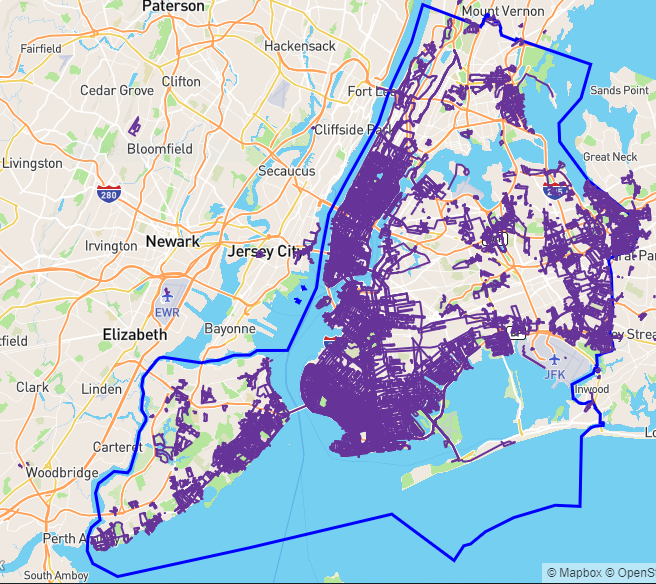
Below is my map of New York City, i.e. the five boroughs (The Bronx, Manhattan, Brook, Queens, and Staten Island) combined. My activities only cover about 25% of the entire NYC so there is much work left to be done. There is no fame or fortune to claim, just bragging rights among friends or friendly competitors. A few people already covered the entire city, measured by some other means. The movie The World Before Your Feet chronicles one such feat. The guy in that movie didn't have a full-time job and achieved the goal in about six years. I have other obligations to satisfy so for now I am happy with my slow progress.

Wouldn't it be nice to visualize all that walking and running on one map? Yes, and that's exactly what the web site CityStrides offer. It is free to use, with some extra features if you pay for a subscription. There are a few subscription tiers, I think anyone with a job should be able to afford the fee, just to support the work of the one man who runs the whole thing.
Below is my map of New York City, i.e. the five boroughs (The Bronx, Manhattan, Brook, Queens, and Staten Island) combined. My activities only cover about 25% of the entire NYC so there is much work left to be done. There is no fame or fortune to claim, just bragging rights among friends or friendly competitors. A few people already covered the entire city, measured by some other means. The movie The World Before Your Feet chronicles one such feat. The guy in that movie didn't have a full-time job and achieved the goal in about six years. I have other obligations to satisfy so for now I am happy with my slow progress.
14 October 2017
SIT ON A POTATO PAN, OTIS AVENUE
I love it when two of my areas of interest intermix. The title of this blog post refers to the phrase SIT ON A POTATO PAN, OTIS. I don't know anyone named Otis or why he was told to sit on the pan. It's just that the phrase is a palindrome – it spells the same from left to right and from right to left. You'll have to ignore the comma and move the spaces around, of course. I first learned about palindromes in a computer class for the BASIC language. Recently I found a new love in CityStrides.com.
CityStrides.com let runners and walkers overlay a map of places they visited. It seems like an impossible task – literally travel along all the streets in your town or places you visited. In my case, that would be primarily New York City. For some reason, out of the five boroughs, Brooklyn and Manhattan are also considered their own individual city.
Work and family constrains do not allow me to cover as much of my hometown Brooklyn as I want to so for now I try to maximize my coverage of NYC instead, as I regularly get sent to Staten Island and also travel through the Bronx. The way CityStrides calculate percent completed has nothing to do with a street's length. For example, let's say a city has a Main Street that goes for miles and miles. Then there are also many streets that only stretch for a few hundred feet. If someone were to focus primarily on completing Main Street while someone else covers all the shorter streets, guess who will have a better completion rate? Yup, not the Main Street guy because by the end of the day, he may have just one out of the total streets completed. Fair enough, really.
In trying to take advantage of this seemingly erroneous percent complete (which really is not erroneous), I try to cover all the short streets whenever possible. Streets that are identified as Place or Lane are usually very short, one- or two-block long. Then I came across Otis Avenue in the Bronx, in the Schuylerville area. Imagine my surprise after walking along it and not finding it considered completed per CityStrides. I searched for it in CityStrides and lo and behold there actually are three different Otis Avenues in New York City. One in the Bronx, another in Queens, not far from Flushing Meadows Park, and yet a third one in Staten Island, just north of Miller Field. The three locations are shown as series of green hexagons in the picture below. Personally I think it is a mistake to consider the three Otis Avenues as three parts of one thing. They just happen to share the name Otis and then also happen to be avenues. New York City was not composed of the five boroughs – Manhattan, Brooklyn, Bronx, Staten Island, and Queens. So at some point before the merger, streets were named independently and Otis Avenue happen to appear three times in the three different boroughs. Just my semi-educated guess, of course. CityStrides gets its data from OpenStreetMap, so if anything is to change it would have to come from OpenStreetMap. Maybe I'll study OpenStreetMap and somehow I.D. the three Otis Avenues with suffix to make them unique to the borough and not considered part of "one street". Highly unlikely I'll mess around with OpenStreetMap, as it seems to be a lot more involved than editing a page in Wikipedia.
Lucky for me, I happened to start participating in NYRR Open Run at Flushing Meadow Park. I usually get there early and have time to walk around. Otis Avenue of Queens was knocked out during my first run at FMP. Next came Otis Avenue in Staten Island, where my son attends high school and I also work there regularly. Easy for me, but I am sure the typical runner who have a job with a fixed office will find it hard to complete these erroneously longer streets. Take that, Otis Avenue, go sit on a pot for all I care!

08 May 2017
THE GREAT SAUNTER 2017, PART 2
The Great Saunter, organized by Shorewalkers, is a 32-mile walk (mostly) on the shores of Manhattan Island. The schedule set forth by Shorewalkers has the walk start at 7:30 AM from Fraunces Tavern near the southern tip of the island. Walkers would go along the Hudson River up to the northern tip then return to the south (mostly) along the East River. Most should finish back at the Tavern by 7 PM the same day.
I don't know what I was thinking but I figured that if I can finish a marathon, distance = 26.2 miles, in 5.5 hours, another 6 miles maybe requires one more hour, so I should be able to finish the Saunter in 7 hours, 8 top. The only trouble is I won't be running, more like a leisurely walk. Yes, in the beginning I wished to catch up to the front of the group so I walked a bit faster than others, but then I also stopped to remove outer layers or to take photos of the surrounding. That was part of the reasons for the walk, to enjoy the scenery. Five hours or so I only finished half the walk, somewhere past the George Washington Bridge. It was kinda like getting off the last exit of the Long Island Expressway, it was the end of the highway but there is actually lots more road to drive on. Lately work has me in the southern end of Staten Island and to me it looks countryside. Houses far apart, no sidewalks in some places. Except in the Inwood area it felt like walking in a forest. The big bridges here and there reminded me I wasn't outside of civilization, then there were also the baseball fields as well as buildings in the Bronx just across the water.
Before we exit Inwood Hill Park, there was a rest area where Shorewalkers staff provided snacks and drinks. Some experience walkers brought along sandwiches and such. I figured we would not be far from civilization and could always stop by a deli to get a sandwich or something to munch. I was lucky the rest area had a green market just across the street from it. I was tempted to have a big lunch but with about 16 more miles to go I had just half a sandwich. And a nice cold apple cider, plus a chocolate chip cookie.
After the break, the route got a little more challenging. So far, it was a matter of having the water of the Hudson River to our left to stay on course. After Inwood Hill Park, we were back in the urban jungle with buildings and traffic in all directions. Unlike those long stretch of shores with few people around, where you can easily spot the walkers far ahead of you, usually with the white Shorewalkers caps, on the crowded city street it wasn't so easy. The organizer prepared a nice map for us but I figured I could find my way to the East River, or to be exact the Harlem River. I got toward the correct general direction but to be safe I asked a trio of fellow walkers waiting to cross the street. It was a fortunate move because even though I was able to walk alone the whole time by then I was getting tired and could use some chit-chat to make the trek more bearable. The trio turned out to be husband-and-wife team P. and T., the other person being a seasoned Shorewalker, C. We stayed together for the rest of the walk, down Harlem River Drive, briefly onto the streets of Harlem, passed over part of the Percy Sutton 5K, then finally along 111th Street to get to the East River waterfront. My favorite part of the walk was in Inwood because I never visited the area before. Even though I haven't been to the waterfront of the Upper East Side in a while, it was familiar territory so it was a bit boring. Still nice and there were surprises, like Gracie Mansion, which I thought was some huge complex with fences and guards, far away from the common folks, but it seemed more approachable than I would, and smaller too, but it may be just from one view.
Among the four of us we share stories about travel, food, walking, CityStrides.com, NYC sights, etc. It helped to pass the time and slowly we whittle down the miles. We had to take restroom breaks here and there and our pace got slower and slower but we soldiered on. It didn't help that the sky became overcast and cooler. At last we saw the Williamsburg Bridge from far away. The home stretch! First Williamsburg, then the Manhattan Bridge, and then not that far away, the Brooklyn Bridge. Unbelievable, all that walking for a paper certificate and bragging right! But it was a lot of fun, much to see in the city no matter how long you live here.
Just as we arrived back at the Tavern to collect our certificates, it started to rain, not heavily, just enough to get the paper certificates wet if we stayed outside. Inside the Tavern it was crowded but we managed to find a table, where they only serve drinks. If I had known ahead I would make some friends, I would make reservations. We had a celebratory drink, took a group photo or two, then parted ways, with contact info exchanged. Just as I stepped back outside, the wind was really strong and I shook uncontrollably! Maybe my body finally reached its limit? Luckily the shaking went away as I kept walking. I even recovered enough to find a Chipotle to have dinner. The subway ride home wasn't so bad, the waiting didn't seem that long.
Oh the agony of the feet! Unlike a marathon where muscles in different parts of the body ache, for me with the Great Saunter, it's mostly with the feet. The smalls of the back hurt a little too. Lucky for me, by Sunday evening, some 24 hours later, I was able to walk normally, mostly. I actually walked over 3 miles to complete a few more Brooklyn streets for CityStrides. The Great Saunter got my Manhattan coverage jumped from 10% to 12%, I should focus some more energy on Brooklyn.
Would I do it again? Probably not, only because I don't like to do things years after years. Maybe in x years when the East Side becomes more continuous I will re-consider it. Shore walkers have many other walks throughout the year, some over short distance like 5 miles but others as long as 10 miles, excellent chances to cover more streets for CityStrides. Should the average, able-bodied New Yorker do it? Definitely! It is a great way to see the City, to visit parts of the City you may never visit! Just be prepared for it, be physically active some time before the big day.
I don't know what I was thinking but I figured that if I can finish a marathon, distance = 26.2 miles, in 5.5 hours, another 6 miles maybe requires one more hour, so I should be able to finish the Saunter in 7 hours, 8 top. The only trouble is I won't be running, more like a leisurely walk. Yes, in the beginning I wished to catch up to the front of the group so I walked a bit faster than others, but then I also stopped to remove outer layers or to take photos of the surrounding. That was part of the reasons for the walk, to enjoy the scenery. Five hours or so I only finished half the walk, somewhere past the George Washington Bridge. It was kinda like getting off the last exit of the Long Island Expressway, it was the end of the highway but there is actually lots more road to drive on. Lately work has me in the southern end of Staten Island and to me it looks countryside. Houses far apart, no sidewalks in some places. Except in the Inwood area it felt like walking in a forest. The big bridges here and there reminded me I wasn't outside of civilization, then there were also the baseball fields as well as buildings in the Bronx just across the water.
 |
| Henry Hudson Bridge, it goes on and on. |
After the break, the route got a little more challenging. So far, it was a matter of having the water of the Hudson River to our left to stay on course. After Inwood Hill Park, we were back in the urban jungle with buildings and traffic in all directions. Unlike those long stretch of shores with few people around, where you can easily spot the walkers far ahead of you, usually with the white Shorewalkers caps, on the crowded city street it wasn't so easy. The organizer prepared a nice map for us but I figured I could find my way to the East River, or to be exact the Harlem River. I got toward the correct general direction but to be safe I asked a trio of fellow walkers waiting to cross the street. It was a fortunate move because even though I was able to walk alone the whole time by then I was getting tired and could use some chit-chat to make the trek more bearable. The trio turned out to be husband-and-wife team P. and T., the other person being a seasoned Shorewalker, C. We stayed together for the rest of the walk, down Harlem River Drive, briefly onto the streets of Harlem, passed over part of the Percy Sutton 5K, then finally along 111th Street to get to the East River waterfront. My favorite part of the walk was in Inwood because I never visited the area before. Even though I haven't been to the waterfront of the Upper East Side in a while, it was familiar territory so it was a bit boring. Still nice and there were surprises, like Gracie Mansion, which I thought was some huge complex with fences and guards, far away from the common folks, but it seemed more approachable than I would, and smaller too, but it may be just from one view.
Among the four of us we share stories about travel, food, walking, CityStrides.com, NYC sights, etc. It helped to pass the time and slowly we whittle down the miles. We had to take restroom breaks here and there and our pace got slower and slower but we soldiered on. It didn't help that the sky became overcast and cooler. At last we saw the Williamsburg Bridge from far away. The home stretch! First Williamsburg, then the Manhattan Bridge, and then not that far away, the Brooklyn Bridge. Unbelievable, all that walking for a paper certificate and bragging right! But it was a lot of fun, much to see in the city no matter how long you live here.
Just as we arrived back at the Tavern to collect our certificates, it started to rain, not heavily, just enough to get the paper certificates wet if we stayed outside. Inside the Tavern it was crowded but we managed to find a table, where they only serve drinks. If I had known ahead I would make some friends, I would make reservations. We had a celebratory drink, took a group photo or two, then parted ways, with contact info exchanged. Just as I stepped back outside, the wind was really strong and I shook uncontrollably! Maybe my body finally reached its limit? Luckily the shaking went away as I kept walking. I even recovered enough to find a Chipotle to have dinner. The subway ride home wasn't so bad, the waiting didn't seem that long.
Oh the agony of the feet! Unlike a marathon where muscles in different parts of the body ache, for me with the Great Saunter, it's mostly with the feet. The smalls of the back hurt a little too. Lucky for me, by Sunday evening, some 24 hours later, I was able to walk normally, mostly. I actually walked over 3 miles to complete a few more Brooklyn streets for CityStrides. The Great Saunter got my Manhattan coverage jumped from 10% to 12%, I should focus some more energy on Brooklyn.
Would I do it again? Probably not, only because I don't like to do things years after years. Maybe in x years when the East Side becomes more continuous I will re-consider it. Shore walkers have many other walks throughout the year, some over short distance like 5 miles but others as long as 10 miles, excellent chances to cover more streets for CityStrides. Should the average, able-bodied New Yorker do it? Definitely! It is a great way to see the City, to visit parts of the City you may never visit! Just be prepared for it, be physically active some time before the big day.
07 May 2017
THE GREAT SAUNTER 2017
A walk on the perimeter of Manhattan Island, 32 miles in more than 12 hours, that was yesterday's The Great Saunter 2017, organized by the good folks at Shorewalkers. I saw some mention of the event before, on Facebook, but more recently I read that some runners had to drop out of it. Decent runners, people who finished marathon distance (26.2 miles), people who are faster than me - couldn't finish the walk. For some it was a nasty blister. I was curious and decided to finally give it a try.
The day before it rained heavily for most of the day. On the day of the walk, it was beautiful weather. Not too hot, but not that cool either. I was not too worried about the preparation, didn't even pin my bib the night before, like on the eve of a big foot race. The D train didn't go to Manhattan from my station so I buffered in some extra time for traveling. It worked out well. I got to Fraunces Tavern with plenty time to spare. There was already two lines from the front door, one for registered users and the other for those who wish to register that day. I didn't recall breakfast being served and asked someone and the answer was no. Not that surprising, it was only $25 to become a member of Shorewalkers and join the walk, I shouldn't expect more for the day. There was a Dunkin Donuts nearby, with no seating, but the plaza across the street from the Tavern had plenty of waist-height horizontal surface to be used as table.
After breakfast I felt the need to flush some stuff out of the system and decided to go inside the Tavern. People were getting inside for buy baseball caps too. I was tempted but I already have too many caps and resisted the urge even to go inside the Tavern, but nature call and it had to be answered. By the time I came out it was already time to move - 7:30 AM or thereabout. People already streamed out what I think of as the backdoor of the Tavern, the one that lead into Water Street. Off we went, in ones or twos, maybe even three, abreast, filing across the street, past the Staten Island Ferry Station, up Hudson River to the tip of Manhattan Island.
The part of the walk that I looked forward to the most was Inwood Park since I never went that far north on Manhattan Island, but I found other pleasant sights along the way, too. Battery Park City looked not that different, but Hudson River Park had some parts that I didn't recognized, like the raised wooden walkway below.
I did take it easy, stopped here and then to take photos. I just wished I took action sooner or later. One building I missed was the "Jenga Building" not far from Borough Manhattan Community College. Instead of just one rectangular tall building, some of the floors seem to be jutting out of the building, Jenga-style. I thought I could get a better view of it after turning into the pedestrian path along the West Side Highway, but by then I was too close to BMCC and it was somewhat foggy too. Lesson learned: If you like something you see, take photos. I no longer have limited space or battery life on my phone so there was no excuse.
One year after an NYRR Coogan's 5K I tried to walk down to Hudson River Park but made the mistake thinking that Riverside Park would easily connect to it. After all, there is the Henry Hudson Parkway between Riverside and the water, so one must cross the highway at some point. Maybe I didn't have enough sleep that day, but I gave up around 86th Street or thereabout. With the Great Saunter, I finally walked up along the entire west side of Manhattan. The best part was the Little Red Lighthouse.
I have heard much about the Little Red Lighthouse but the one time I tried to find it while I was in the area, without any software or map program, I failed. On the Great Saunter, it was not out of the way too, just a few steps off the course. I took a little break here to check-in on Facebook as well as sip a little water. It was a cool day, I didn't need much water.
For a while then we were walking way below the Hudson Parkway. It was time to climb up to its level, at which point Strava said I reached the 16-mile mark so it was time to stop the program just to be safe. One reason I do the Great Saunter was to improve my Manhattan map on CityStrides.com. I already had 10% of Manhattan covered, a long walk around the perimeter should increase that number somewhat. I would hate to lose the phone or run out of battery power before saving the effort. So at the midway point, I stopped the app and re-started anew. First 16 miles, second half 16 miles, whatever happened during the second half, I know at least the first half will be safe. Speaking of half, I better write the other half of this blog post tomorrow, it is time for me to go to sleep.
The day before it rained heavily for most of the day. On the day of the walk, it was beautiful weather. Not too hot, but not that cool either. I was not too worried about the preparation, didn't even pin my bib the night before, like on the eve of a big foot race. The D train didn't go to Manhattan from my station so I buffered in some extra time for traveling. It worked out well. I got to Fraunces Tavern with plenty time to spare. There was already two lines from the front door, one for registered users and the other for those who wish to register that day. I didn't recall breakfast being served and asked someone and the answer was no. Not that surprising, it was only $25 to become a member of Shorewalkers and join the walk, I shouldn't expect more for the day. There was a Dunkin Donuts nearby, with no seating, but the plaza across the street from the Tavern had plenty of waist-height horizontal surface to be used as table.
After breakfast I felt the need to flush some stuff out of the system and decided to go inside the Tavern. People were getting inside for buy baseball caps too. I was tempted but I already have too many caps and resisted the urge even to go inside the Tavern, but nature call and it had to be answered. By the time I came out it was already time to move - 7:30 AM or thereabout. People already streamed out what I think of as the backdoor of the Tavern, the one that lead into Water Street. Off we went, in ones or twos, maybe even three, abreast, filing across the street, past the Staten Island Ferry Station, up Hudson River to the tip of Manhattan Island.
The part of the walk that I looked forward to the most was Inwood Park since I never went that far north on Manhattan Island, but I found other pleasant sights along the way, too. Battery Park City looked not that different, but Hudson River Park had some parts that I didn't recognized, like the raised wooden walkway below.
 |
| Hudson River Park boardwalk. |
One year after an NYRR Coogan's 5K I tried to walk down to Hudson River Park but made the mistake thinking that Riverside Park would easily connect to it. After all, there is the Henry Hudson Parkway between Riverside and the water, so one must cross the highway at some point. Maybe I didn't have enough sleep that day, but I gave up around 86th Street or thereabout. With the Great Saunter, I finally walked up along the entire west side of Manhattan. The best part was the Little Red Lighthouse.
 |
| Little Red Lighthouse |
For a while then we were walking way below the Hudson Parkway. It was time to climb up to its level, at which point Strava said I reached the 16-mile mark so it was time to stop the program just to be safe. One reason I do the Great Saunter was to improve my Manhattan map on CityStrides.com. I already had 10% of Manhattan covered, a long walk around the perimeter should increase that number somewhat. I would hate to lose the phone or run out of battery power before saving the effort. So at the midway point, I stopped the app and re-started anew. First 16 miles, second half 16 miles, whatever happened during the second half, I know at least the first half will be safe. Speaking of half, I better write the other half of this blog post tomorrow, it is time for me to go to sleep.
21 October 2012
TWENTY MILES TO CHARITY MILES
With two weeks to go until the New York City Marathon, everywhere I read the message is "taper off". No more long-distance runs, just maintenance workouts to keep thing moving. Don't race, don't risk getting yourself hurt. But I haven't done my 20-mile run recently! I am not really following any training plan anyway, so my plan, if it can be called as such, is to do a 20-mile run THEN taper off. I really admire people who follow the various plans out there exactly.
My plan for today was to run 20 miles then join a Charity Miles group walk departing from Times Square. In the past, my 20-mile run consisted of running from Brooklyn, in the Coney Island area, toward or into Manhattan. The first time I carried out a 20-mile run, I didn't have a GPS watch and prepared for it by using the measuring tool on DailyMile.com. I ran mostly along the D train's elevated tracks then along Fifth Avenue toward Manhattan Bridge. I entered Manhattan via the Manhattan Bridge, before the sun came up, and returned to Brooklyn over the Brooklyn Bridge, then traced my way back to Bath Beach. More recently, in preparation for the Yonkers Marathon, I ran with a Garmin and went along the Belt Parkway waterfront then Second Avenue, followed by Third Avenue then along the BQE but on the waterfront, with Brooklyn Bridge Park being the turning-back point. The duration for both occasions were a little over four hours. I am a slow runner.
For today's run, by the time I got into Manhattan, I already covered more than ten miles and realized I was far less than ten miles from Times Square. I was in Chinatown and planned to get to the West Side Highway to go uptown along the waterfront. There are twenty Manhattan blocks to a mile, so Times Square, being around 42nd Street is at least two miles away. Tack on the non-number streets from the Village to Chinatown, at most it would be another two miles. Since I had to get from the Manhattan Bridge to the West Side Highway then cut cross-town to get to Times Square, surely there would be a few more miles? Once I got to the West Side Highway, I didn't worry about the mileage. The sun was out, the weather was beautiful, I shed the top outer layer and ran in shirt and shorts only. At Chelsea Pier, I followed a runner and made a big loop around the golf driving range. I don't get to run on the west side of Manhattan much. The last time I did I ran south from 72nd Street and supposedly had to share the road with cyclists. Today I followed other runners and was able to run mostly along the waterfront, where most cyclists did not venture to. One of these days I must run all the way up past the George Washington Bridge and loop over to the east side. For today, I ran cross-town at 45th Street, not 42nd Street, because I wanted to avoid all the tourists. By the time I got to the Tasti D-Lite in Times Square to meet other Charity Miles participants, I got 25 km, or about 17 miles, covered. If I had more time or were able to run faster, I probably could have included all the finger piers, i.e. those long piers that jutted out in the Hudson River, along the way to get to 20 miles, or more.
In today's social networks, most of the time we "meet" people online (in cyberspace) and not in real life, aka meatspace. I got to know the Facebook friend M., denoted below as a caricature I drew last night, through a word game. She got me into using Charity Miles to raise money for charities while out running/walking/cycling. The app Charity Miles is available for iOS and Android. I still haven't met M. but today I got to meet the founder of Charity Miles, Gene Gurkoff, and as a bonus, his mother Stevi. Besides having a face to go with the names, we got to talk about a few topics to find out more about each other. In the group of twenty or so walkers, there were visitors as well as NYC residents. Among the visitors were AKStout and Deb Evans of the online radio show, Social Geek Radio. Both AK and Deb love the apps and got Gene onto the show a few times and today they flew in from Texas and Baltimore to do walk. They sure talk the talk and walk the walk, no? The group went to Central Park and made stops at Rockefeller Center, St. Patrick Cathedral (which was covered by scaffolds), and the Plaza Hotel. I had other matters to attend to and couldn't stay for the entire 6.5-mile walk and took off shortly after we entered the park.
By the time we got to Central Park, I got about 2 miles on my Android phone and decided to play safe and finished the workout. Maybe it's just my FroYo Android phone, I always have troubles accepting sponsorship for the miles. During the Staten Island Half-Marathon two weeks ago, I got about 6 miles recorded but then somehow the app died and I had to restart all over. I only got a few Charity miles out of the 13.1-mile race. When it successfully records the workout, it rarely ever uploads the data without requiring me to power off the phone and turn it back on, sometimes with having WiFi enabled and then disabled. The error message is that there was no Internet connection, although other 'Net-centric apps like Facebook and Mail would work just fine. Gene told me that a new update is coming soon, so perhaps the issue will go away.
 |
| M recently got into running and dieting, which resulted in lots of weight loss. |
 |
| Moi, Stevi, and Gene. Colorful shirts we got, I must say! |
24 July 2009
Crossing Williamsburg Bridge
I love walking and especially walking over long bridges. It helps to live in a city like New York. Years ago, when I was done with jury duty early I walked across the Brooklyn Bridge to eventually catch the L train to get back home in northern area of Brooklyn. It took me 40 minutes. I was not married and life was simpler. When the Manhattan Bridge was opened to pedestrian traffic, I no longer had the spare time to walk across it just for the heck of it. Same thing for the Williamsburg Bridge. Recently, I had the rare opportunity of killing a few hours while my son and his cousins take their swimming lesson. The pool building is in the shadow of the Williamsbug Bridge and the Bridge called my name so off I went. It took half an hour each way. With its protective fence, the Williamsburg Bridge is certainly not a photographer's dream. With the simple camera in my cell phone, I couldn't snap anything better than the ones shown below.
Subscribe to:
Posts (Atom)