10 January 2016
UNSET IN SUNSET PARK
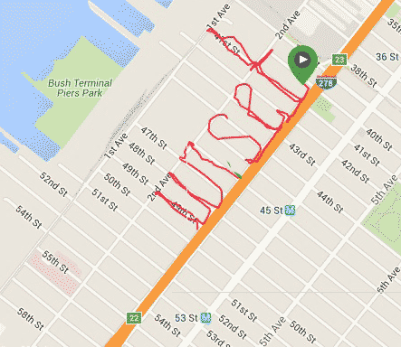
Continuing my philosophy of "slow progress is better than no progress" today I resumed "writing" Sunset Park. I thought I only had enough time for two lowercase letters, so "un" it was, i.e. Sunset still needs the uppercase S. Below is the doctored image with "un" and "set" combined. There was a second green marker to denote the start of today's walk, but I don't like those things so I left it hidden in the lower layer. Only a trace of green shows in the combined image. The area was desolate and it was getting dark, the rain was coming down again, so it was good that I didn't attempt to complete Sunset. Any day now, any day now. We seem to go to Costco once a month so if I don't finish this in January, by February it will be done!
03 January 2016
SET IN SUNSET PARK
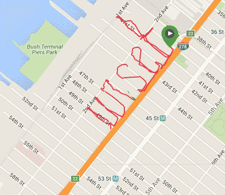
What a great feeling it is once you are resolved to do something and make modifications to your plan to achieve the final outcome. So I decided I would walk if I have to, instead of running, just to complete my run-mapping of Brooklyn. Running is more interesting but not always optimal, like after a meal. Just a few days ago I churned out "Slope", for Park Slope, after a brunch with the track club. Today I was in the neighborhood of Sunset Park and had a little time for running. Not enough to do the entire "Sunset Park", or even the word "Sunset", but that is not a problem. I am already stitching together the map in Photoshop, no harm to do one syllable at a time, like "set" as in "Sunset". "t" didn't come out a straight as it should but it's beyond my control. I guess at different time of day the satellite can be uncooperative. Perhaps when I stitch "set" together with the other syllables it won't look so bad.


02 January 2016
HAPPY NEW YEAR - BROOKLYN RUN-MAPPING RETURNS
Happy New Year! I didn't declare it but deep down I know I want to resume blogging. There should be only so much Facebooking one can do. Be more of a content producer, not just a mere Liker and Bait-Clicker. Without much further ado, here's a topic close to my heart, running and spelling out the neighborhoods of Brooklyn! I prefer to call it Run-Mapping!
I should have known better but as I was done with the areas close to where I live, things get more challenging. I have this weird rule about running - no driving to the place to run. In other words, I should not drive x miles out to some place just to run around. I guess it has to do with my strong dislike of driving. If I am to complete this run-mapping of Brooklyn nabes, sooner or later I'll have to drive to where I want to run. Until such time, I'll make the most of my travel.
Late in December I ran to Marine Park just to spell "Park". Marine Park is about 5 km from me so spelling the whole "Marine Park" was not possible time-wise. Lately on these runs I have one or two phone apps to track my "writing". At one time I even thought if not for this run-map project, I probably can retire my Garmin GPS watch. The apps work the same way with regards to pause and resume, so I can use them to virtually cut through city blocks to make letters like K and R with their pesky diagonal lines. When they actually work as they are supposed to, that is. On the "Park" run, they didn't. Both Strava and MapMyFitness totally miss the P and then went crazy the rest of the run. Luckily, I did have the trusty Garmin, even though the lack of a rectangular city grid threw me off my course. As shown below, "Pa" is a big disappointment, even to a non-perfectionist like me. The "a" is too far away from its neighbors and "r" looks too much like an "n". I should have done my usual virtual trespassing in making the diagonal lines in "k". I use the picture in the map anyway but deep down I know I will re-run that route to make a better word.
Even though I am a member of the Prospect Park Track Club, I don't go to Prospect Park that much. Living far south almost in Coney Island, it's a bit of a trip for me. But I do go there from time to time and I should take advantage of those trips to finally add Park Slope and neighbors to my map.
On New Year's Day, I volunteered as a backup time-keeper for the Club's Harry Handicap race, held in Prospect Park. After the race, I had some food and was in no shape to run so I did the next best thing to spell out "Slope" - I walked. It was not as interesting as running but for these far-flung places I just have to make the best of my time. Again, MapMyFitness screwed up but Garmin Forerunner again saved the day. I gladly used the picture in the big map although there are many more street blocks I need to capture to make the map truly continuous.
Given the annoying changes Garmin make to its web site, I should hurry up and run more neighborhoods sooner before some changes render my techniques useless. Wish me luck!


I should have known better but as I was done with the areas close to where I live, things get more challenging. I have this weird rule about running - no driving to the place to run. In other words, I should not drive x miles out to some place just to run around. I guess it has to do with my strong dislike of driving. If I am to complete this run-mapping of Brooklyn nabes, sooner or later I'll have to drive to where I want to run. Until such time, I'll make the most of my travel.
Late in December I ran to Marine Park just to spell "Park". Marine Park is about 5 km from me so spelling the whole "Marine Park" was not possible time-wise. Lately on these runs I have one or two phone apps to track my "writing". At one time I even thought if not for this run-map project, I probably can retire my Garmin GPS watch. The apps work the same way with regards to pause and resume, so I can use them to virtually cut through city blocks to make letters like K and R with their pesky diagonal lines. When they actually work as they are supposed to, that is. On the "Park" run, they didn't. Both Strava and MapMyFitness totally miss the P and then went crazy the rest of the run. Luckily, I did have the trusty Garmin, even though the lack of a rectangular city grid threw me off my course. As shown below, "Pa" is a big disappointment, even to a non-perfectionist like me. The "a" is too far away from its neighbors and "r" looks too much like an "n". I should have done my usual virtual trespassing in making the diagonal lines in "k". I use the picture in the map anyway but deep down I know I will re-run that route to make a better word.
Even though I am a member of the Prospect Park Track Club, I don't go to Prospect Park that much. Living far south almost in Coney Island, it's a bit of a trip for me. But I do go there from time to time and I should take advantage of those trips to finally add Park Slope and neighbors to my map.
On New Year's Day, I volunteered as a backup time-keeper for the Club's Harry Handicap race, held in Prospect Park. After the race, I had some food and was in no shape to run so I did the next best thing to spell out "Slope" - I walked. It was not as interesting as running but for these far-flung places I just have to make the best of my time. Again, MapMyFitness screwed up but Garmin Forerunner again saved the day. I gladly used the picture in the big map although there are many more street blocks I need to capture to make the map truly continuous.
Given the annoying changes Garmin make to its web site, I should hurry up and run more neighborhoods sooner before some changes render my techniques useless. Wish me luck!


29 November 2015
I HATE DRIVING
Recently I found out belatedly that, back in September, there was a Car-Free Day. Or something to that extent. Maybe it was Use-The-Car-As-Little-As-Possible Day. Might as well that I didn't know about it, because with my current job I wouldn't be able to participate anyway.
In all my years of holding a job, I was lucky to be able to do so with taking public transportation, mostly. Sure, going to Jersey City tacked on at least an additional 25 minutes, or more when the PATH misbehaves, but still I didn't have to watch out for other drivers or look for parking once I got to work. Nowadays I spent at least 2.5 hours on the road, that's just getting to work and back. Some days I may have to visit three different client sites, no fun. Driving itself is tiresome but parking is not much better. I used to think that only busy areas like Midtown Manhattan, or maybe the entire Manhattan, and some commercial districts, have severe problems with parking. But no, you can be out in the boondocks of western Long Island and there is still a shortage of parking space. Over the few months that I've been a car-commuting worker, I came up with a few workarounds to soften the blow. Mostly with driving, parking not so much.
- Don't stick to just one route. Easy said than done in some scenarios, but always worthwhile to explore. I used to think the Cross Island Parkway is a great alternative to the Van Wyck Expressway, northbound anyway, because I took the CIP occasionally on weekends. Now that I need it during rush hours, fuhgeddaboutit! Even as early as 6 A.M. there would be cars heading to the Bronx via the CIP. It took me many tries but eventually I found a great local route that mostly runs along the CIP and not have to deal with the lousy traffic. It may not be faster but it sure is headache-free.
- Let technology work for you. It can be low-tech like the radio and its traffic report, or high-tech like Google Map and Waze. I get a great kick out of knowing ahead where the traffic jam ends and re-enter the highway just beyond the jam. It does not always work, but it's a wonderful feeling when it does.
- Along the same note, use technology to find alternate routes. The new route does not have to replace the old one completely, just to avoid some sucky section is good enough. I used to hate the part of the Conduit Avenue North around 135th Avenue or 140th Street where the right lane forces a right turn. One day I decided to see where the right turn would lead me and lo and behold while you'll be a bit off-target from your destination traffic is much better than going through the busy intersection of the Van Wyck and the Belt. While some days I don't mind going slowly with traffic while my favorite podcast is on, most of the time I just want to quickly be done with the car trip. Having the optimal route is the way to get that done soonest.
- I don't know how I used to do it with paper maps but turn-by-turn driving direction is a wonderful thing. Especially when you go to an unfamiliar destination. Most of the time the street signs are tiny and useless. By the time you read what it says, with the jerk behind you honking madly, you already missed the turn and have to somehow loop back. Note that I didn't say make a U-turn. I absolutely hate it when drivers make a U-turn on a narrow street.
- Remember I said for parking I found no solace? It's a matter of luck. Or if you don't mind making crazy U-turns. One thing I found out is, if you are like me and not mind walking long distances, sometimes there are residential area near your destination that you can park at. Of course I've come across some towns that have local regulations forbidding street parking, like between 9 AM and 6 PM, but most of the time free parking can be had a few blocks away. Again, you can use Google Maps or the like to scope out the area before you get there. Usually an overhead view of the area is enough for me, but maybe you can go full-blown and use Street Maps and such.
I am no Traffic Sam, as I know just a tiny portion of the big NYC metro, but if any of these tips help someone saves a little time or a few drops of gasoline, then I am happy.
26 October 2015

18 October 2015
WELCOME TO BAY RIDGE ETC
Welcome to Bay Ridge and Dyker Heights, the two neighborhoods I recently added to my Brooklyn GPS map. The map really needs to be expanded to include other neighborhoods but work has kept me busy. I know, I know, Manhattan Beach still does not have its beach and Bath Beach should be further to the west. So many nabes, so little time.
I must note that Bay Ridge was somewhat challenging in that its east-west streets are wider than the north-south ones. I ended up using lots of iTrespassing to make the lowercase letters half-a-block wide. It was a decision I made while out running. In the planning stage, I was going to use the entire block's width, thus would not have enough width to spell Ridge, so I started the e in Dyker Heights and it unfortunately overlaps the D in Dyker. Another word to re-write some day perhaps...

I must note that Bay Ridge was somewhat challenging in that its east-west streets are wider than the north-south ones. I ended up using lots of iTrespassing to make the lowercase letters half-a-block wide. It was a decision I made while out running. In the planning stage, I was going to use the entire block's width, thus would not have enough width to spell Ridge, so I started the e in Dyker Heights and it unfortunately overlaps the D in Dyker. Another word to re-write some day perhaps...

30 August 2015
BEAST PACING
I love running and already explored different areas of the sports. I've run various distances from 5K to full marathon. I volunteered/worked as course marshal, lead cyclist, water station staff, bag-checker, photographer, etc. Something new I'm about to get into is pacing, that is, running a race at a specific pace holding a corresponding sign so that other runners of that pace can follow. Or pass me if they choose to. My first pacing race will be the Run and Ride Half Marathon at Dorney Park, http://www.runandriderace.com/#!dorneyparkhalf/c24p1 . The company that coordinate pacers and race organizers is Beast Pacing, http://beastpacing.com . I love encouraging runners so I really look forward to the race. I just hope they don't run with headphones so that my words of encouragement won't go to waste. I myself don't run with headphones whatsoever. Here's to Beast Pacing!
The images are made from two route arts, from my morning runs yesterday (Saturday Aug 29) and today (Sunday Aug 30), digitally combined.

The images are made from two route arts, from my morning runs yesterday (Saturday Aug 29) and today (Sunday Aug 30), digitally combined.

22 August 2015
A BEACH IN BROOKLYN
Having a job is nice but being at work 9 hours a day plus 2+ hours driving back and forth and you then don't have time for fun things, like running and tracing out words that represent the locale. Even with some new pairs of running shoes to test out I didn't add any new neighborhoods to my GPS Brooklyn map. I finally got around to putting on a new pair of Kismet Core Pop from Newton Running and made the "Manhttn" map below, for the neighborhood of "Manhattan Beach". I know, a few vowels are missing but I really did not have much width and height to work with. Hampton Avenue only runs so far east. While I can go as far as the gate of Brooklyn Community College, I wouldn't have the necessary two-avenue height to make the t's stand out. Using artistic license and dropping the a's is the way to go. Sorry, Manhattan.
For work, I drive by the area everyday, via the Belt Parkway, so one of these days I'll just stop by and spell the shorter version of Beach, namely "Bch". Yeah, I know the neighborhood border on the west is West End Avenue. In planning the route, I realized that if I stick to that, the second t would not have room to display its horizontal stroke. So invade Brighton Beach, at Corbin Place, I did.


For work, I drive by the area everyday, via the Belt Parkway, so one of these days I'll just stop by and spell the shorter version of Beach, namely "Bch". Yeah, I know the neighborhood border on the west is West End Avenue. In planning the route, I realized that if I stick to that, the second t would not have room to display its horizontal stroke. So invade Brighton Beach, at Corbin Place, I did.


25 July 2015
BRIGHTON BEACH MEMOIRS
After a two-hour car drive in yucky NYC traffic to go from the Coney Island area to the High Bridge Celebration, I felt pretty lousy. The festival was good but since I just visited the area a few weeks back for the High Bridge 5K Trail Race, it was not as big a novelty as it could be. The long car drive didn't help. I salvaged the day by completing my push to put Brighton Beach, Brooklyn on my map.
It was quite a challenge to add the Beach to the seaside town. There was not much vertical room to work so I had to use the beach area. In the beginning, I walked with my running shoes but after a while I decided to blend in by walking barefoot. As a bonus, I was able to walk right into the lapping waves, aaahhh. Note that not only I didn't have much vertical space to maneuver in, because of construction, the Boardwalk ends at Coney Island Avenue, where the h is. I spelled backward from the h and used MapMyRun's on-screen path to make sure I have enough space between the letters. Everything went well until B, which turned out to have too small a belly. Oh well, it's a busty B, or maybe it's just upside down.

Speaking of Brighton Beach memories, here is what used to be "my" first home in the U.S. This is the corner of Brighton 1 Street and Neptune Avenue. Neptune runs left to right whereas Brighton 1 is where the five cars point to. The road used to be one-way the other way. My first night in the U.S. was spent in a house that would be where where the white car (fourth in the line) is. Oh well, the price of commercialism. Maybe someday when I become rich and famous I can buy the new building to knock it back down and rebuild the old home from a photo my #1 Blog Fan has.

It was quite a challenge to add the Beach to the seaside town. There was not much vertical room to work so I had to use the beach area. In the beginning, I walked with my running shoes but after a while I decided to blend in by walking barefoot. As a bonus, I was able to walk right into the lapping waves, aaahhh. Note that not only I didn't have much vertical space to maneuver in, because of construction, the Boardwalk ends at Coney Island Avenue, where the h is. I spelled backward from the h and used MapMyRun's on-screen path to make sure I have enough space between the letters. Everything went well until B, which turned out to have too small a belly. Oh well, it's a busty B, or maybe it's just upside down.

Speaking of Brighton Beach memories, here is what used to be "my" first home in the U.S. This is the corner of Brighton 1 Street and Neptune Avenue. Neptune runs left to right whereas Brighton 1 is where the five cars point to. The road used to be one-way the other way. My first night in the U.S. was spent in a house that would be where where the white car (fourth in the line) is. Oh well, the price of commercialism. Maybe someday when I become rich and famous I can buy the new building to knock it back down and rebuild the old home from a photo my #1 Blog Fan has.

22 July 2015
WELCOME TO BRIGHTON BEACH, WELL, ALMOST
The past two days were hot and humid. I didn't get up early enough to beat the heat, i.e. run at 5 AM or so. Today I made up by running "Brighton", as in Brighton Beach. I didn't like the fact that the area is small, with few large rectangular blocks to work with. I thought of skipping it but then Eugene Morris Jerome may be upset. My first night in the U.S. some 30+ years ago, I did sleep in a house in the area. It belonged to an uncle but he has moved away since then. The new owner knocked down the house, along with a few adjacent ones, and a big building is being constructed on the lot.
I knew that the area has these mouthful Brighton 1 Street and 2 Street etc but did not know about all the alleys that in other parts of town would just remain nameless. There were Brighton 5 Walk, Brighton 5 Court, Brighton 1 Path, etc. Most of these so-called streets are narrow and are mere empty space between two houses. It is nice to have them nonetheless although I would not use them late at night.

I knew that the area has these mouthful Brighton 1 Street and 2 Street etc but did not know about all the alleys that in other parts of town would just remain nameless. There were Brighton 5 Walk, Brighton 5 Court, Brighton 1 Path, etc. Most of these so-called streets are narrow and are mere empty space between two houses. It is nice to have them nonetheless although I would not use them late at night.

 |
| T-intersection of Brighton 1 Path, which continues to the right of the tree, and Brighton 1 Walk, which runs from the foreground of the photo to the background. |
 |
| Brighton 5 Court, which simply connects Brighton 5 Street to Brighton 6 Street. It is relatively wide compared to other named alleys in the area. I recall one really narrow alley with overgrown weed and three or four guys sitting in the middle of the road. Mugger paradise! |
18 July 2015
WELCOME TO SHEEPSHEAD BAY!
My Brooklyn map-building continues to crawl forward, slowly. The latest three runs put Sheepshead Bay on the map, so to speak.


To round out the coastal towns, next I will have to do Brighton Beach, which is immediately to the east of Coney Island, and Manhattan Beach, right below Sheepshead. Both are tiny towns compared to Sheepshead Bay, with insufficient room to spell out the whole words. I'll have to compromise somehow.
08 July 2015
WELCOME TO CONEY ISLAND!
Welcome to Coney Island! Some time ago I ran the route for "Coney" but never got around to adding "Island", until this week. It is a good thing that I took advantage of the open space in Leon Kaiser Park to make most of "Coney" because the island (which is not really an island any more) is not "tall" enough to give me much room to work with. I thought of using the space between the Boardwalk and the beach but running on sand is no fun. I studied what was available and what I did with "Coney" and concluded that I could do it with Surf Avenue and the Boardwalk. Because of constructions, some streets no longer led to the Boardwalk but good thing I have that one trick in my bag. I just had to run back and forth over some streets, but technically I can cut through walls and other objects. For the I, I could have jumped off the Boardwalk and land on the sand below but to be safe I used my technique.
Onward to Sheepshead Bay!

Onward to Sheepshead Bay!

07 July 2015
WELCOME TO GRAVESEND AND BENSONHURST
Welcome to Gravesend and Bensonhurst! It took a few runs to have it done correctly but it is worthwhile. The second e in "send" is not perfect, but that will do. "Bensonhurst" was created from scratch, now a few blocks north of Bath Beach border. I probably will re-do Bath Beach to move it westward toward 14th Avenue and away from Gravesend.
The next neighborhoods I'll put on the map, so to speak, will probably be those to the east and south of Gravesend, just to round things out. Such as Coney Island and Sheepshead Bay. Afterward I'll march northward to connect to Prospect Park, since I have many friends living up there, they may appreciate it.

The next neighborhoods I'll put on the map, so to speak, will probably be those to the east and south of Gravesend, just to round things out. Such as Coney Island and Sheepshead Bay. Afterward I'll march northward to connect to Prospect Park, since I have many friends living up there, they may appreciate it.

12 June 2015
WELCOME TO BROOKLYN
So I did not win the Newton Running route art contest. Did not even get to be one of the three finalists having a shot at winning shoes for life plus a GPS watch. After a short time feeling unhappy about it, I decided to start a new, very ambitious project: create a map of all the Brooklyn neighborhoods through run art. It is ambitious indeed as I don't know all the neighborhoods. Sure I can start with my own area and adjacent ones, but the thought of driving elsewhere just to run a route sure is not appealing to me. The thing is once I am done, whenever that is, I'll know a lot more about Brooklyn.
I belong to a NextDoor.com neighborhood made for Bath Beach residents so the first nabe I ran was Bath Beach. I made two separate runs and stitched the two pieces together. I am not that happy with the B in Bath and may re-run the route one of these days. Next I thought I would cover my own turf and ran "Grave" for Gravesend. I did feel something odd when I started to create the V, sure enough once I got back I discovered that the "r" and the "a" are stuck together. It was good that I decided early on to make Gravesend in two separate runs. No point of putting a lot of time into a run only to find out that it's no good. These days I run in the evening any way and dinner seems to come too soon each time, that is I have time constraint.
Today I was supposed to re-run Grave but I happened to be near Bensonhurst so I made "Benson". While "Benson" itself came out perfect, I made it too close to the border of Bath Beach and Bensonhurst such that when stitched Bensonhurst to the bigger map, the letters overlaps, rats!
Here is the work-in-progress map, warts and all. Slowly and surely I will have the entire Brooklyn represented as route arts.

I belong to a NextDoor.com neighborhood made for Bath Beach residents so the first nabe I ran was Bath Beach. I made two separate runs and stitched the two pieces together. I am not that happy with the B in Bath and may re-run the route one of these days. Next I thought I would cover my own turf and ran "Grave" for Gravesend. I did feel something odd when I started to create the V, sure enough once I got back I discovered that the "r" and the "a" are stuck together. It was good that I decided early on to make Gravesend in two separate runs. No point of putting a lot of time into a run only to find out that it's no good. These days I run in the evening any way and dinner seems to come too soon each time, that is I have time constraint.
Today I was supposed to re-run Grave but I happened to be near Bensonhurst so I made "Benson". While "Benson" itself came out perfect, I made it too close to the border of Bath Beach and Bensonhurst such that when stitched Bensonhurst to the bigger map, the letters overlaps, rats!
Here is the work-in-progress map, warts and all. Slowly and surely I will have the entire Brooklyn represented as route arts.

07 June 2015
SCENES FROM A RUN: GREAT KILLS PARK
I don't hate driving per se, it's the parking part that I hate. Luckily, this is Staten Island, the one borough of New York City that not that many New Yorkers visit. I drove into the park and even near the main entrance near Hylan Boulevard there were some parking spots. I kept driving further, I wanted to go as far as I could by car then explore the rest of the park on foot. Parking Lot G was the furthest I could go. Beyond that you would need a permit of some sort. There was plenty of parking spots and there was no booth to collect tolls so I supposed it's free parking. Kinda sad how I thought that way, elsewhere in New York City it costs a fortune to leave your car in a safe place, to avoid getting ticketed.
I already had running clothes on the inside, so just removing the outer layer, a few minutes of stretching and off I went. To be safe, I started with the multi-use path, there were already a few walkers and runners. Not too long afterward the road ended and I took the sandy path on the left to go toward the beach. On the beach I turned northwest to get to Crooke's Point. The run became more of a walk, I rescued two overturned horseshoe crabs and watched them slowly re-entering the sea without saying thank-you. There were a few fishermen out on the beach, some with kids. The waves lapped at the sand but there was always enough room to go along. After Crooke's Point, there was a rocky wall and a road paved with gravels. I resumed running but took time out to snap photos of some sleeping ducks. What a life, just lounging around with beaks in their back. At the end of the gravel path, I was back at Parking Lot G.
I already covered about 5 km so I figured it would run 5 more km for an even 10. As I ran toward park entrance, a raccoon calmly crossed the road to get into the bush. The park has some some wild sections closed off to visitors, either by fence or bush, the 'coons are very much at home. At the 6 km mark, I planned to run for another 2 km then U-turn to reach the 10 km. However, at Parking Lot F, I decided to go along the nice waterfront and unknowingly curved away from the park entrance. I kept following the road and eventually found myself back on Hylan Boulevard. Sure I could still U-turn but there was no fun in that. I had a good idea where the park entrance was and found my way there and eventually got back to Parking Lot G. The distance came out 12 km, a hot and humid km's more than planned.

 |
| I was there! |

 |
| Lucky duckies. |

 |
| These two horseshoe crabs became some seagulls' dinner. |
 |
| Whatever species these flowers are, I stopped and smelled them. |
04 May 2015
LONG ISLAND MARATHON 2015
While I would love to run a marathon in every U.S. state, I don't have the money for the plane tickets and hotel stays. Luckily I live in New York City and there are a few marathons in the city and nearby. Yesterday I was able to take the Long Island Marathon off my wish-list.
Back on the last day of the year 2014, before registration price go up, I signed up for the race, for $65.35. It's relatively inexpensive compared to other big-name marathons. The one hassle is that packet pickup had to be done on the Friday or Saturday before race day, out in Nassau County. I have a car so it was not too bad, even though I did have trouble finding the place, Mitchel Athletic Field. It was not listed in iOS Google Maps as such, I happened to find it by taking some guesses. The place can be reached by LIRR but it probably would take some extra time. I encountered two small issues at packet pickup. Once you are past security check, on the right there were two separate lanes, one for Walk-In Registration, and the other, by process of elimination, Packet Pickup. If you are not careful, you may miss the two lanes altogether and end up in the expo area. I think it would be nice if there was a staff right at the entrance directing traffic. Packets are sorted by bib numbers, which was sent out late in the week of the marathon, if you don't have it there are computers for you to use to look things up. Again, I think it would be nicer if there was a staff by the machine to tell people what to do. I was going to use the machine, just because I didn't know what they were for, but then I realized they were for looking up bib numbers, so I skipped the line and went to get my bib.
The expo was conveniently located right outside packet pickup. I was tempted to sign up with the inaugural Suffolk Marathon to take advantage of the current price but I held back. Let's finish the Long Island Marathon first. I was good at not buying or even asking for free stuff as I strolled through the expo. After a while there are just so many running accessories I can use. I could have picked up some Gu gel or equivalent but a few days earlier I already got a box from the local Jack Rabbit Sports. Almost by the exit of the expo area that runners get their bling bag. While the bag content was nice, again no one was on the floor directing traffic. I could have easily walked out of the expo without picking up my bag, which includes a medium towel, race shirt (black, not a good choice for the sun), lanyard, and some promotional literature. I think bling bag's table should be immediately near the bib table.
On race day, I got to the parking lot near the Ice Rink of Eisenhower Park early. The walk to the start area was a little over a mile. I got there just in time to meet a few members from Prospect Park Track Club. After a short wait, we went to our separate pace groups. I had to step aside from the start line to have my Garmin GPS pick up satellite signal. At least I remembered to charge it the night before and brought it with me. At a previous race, I was so out of organized racing that I totally forgot about my Garmin. For all its old technologies, my Garmin is still the best I have for recording time for a marathon. No way the iPhone battery would last long enough.
For once, I didn't think to myself, "Why am I running this?" or something along that line. Even though I knew I didn't train enough for it, I just ran at my best, one mile at a time. I started slow, there were many half-marathoners, in the thousands, running along with the 600+ full-marathoners, so I was ready to wait for the split where the Half runners leave me. I skipped the first few water stations but had my first Gu gel with water etc one hour in. I had a long-sleeve tech shirt on the inside, with my track club singlet on the outside, but soon enough it got pretty hot. To avoid losing time to wardrobe change, I waited until the HM split before removing the inner layer and ran with just the singlet. By the half-way point, 13.1 mile, I was exactly 2:30 on the race clock. Considering I crossed the start mat 2 minutes after gun time, I couldn't help wishfully thinking that I would have the race done under 5 hours.
Some time ago someone told me that the worst stretch of the Long Island Marathon is the highway portion. They meant the Wantagh Parkway. Once the half-marathoners went their separate way, there were just a handful of marathoners on the long stretch down the Parkway. I studied the course map briefly before the race and knew that at some point there would be a U-turn on the Wantagh for the marathoners to head back to Eisenhower Park. It shouldn't matter which mile mark that is but I asked an official-looking guy anyway. He said Mile 14 or 15, but it turned out to more like Mile 16.5. Whatever, it was still x miles to go no matter where the turnaround is. It just felt better that a milestone is reached.
Things got really lonely on the highway so I struck conversation with other runners as I tried to pass them. Or crack jokes with the volunteers at water stations, as well as thanking them. After the U-turn, the sun really beat down on the runners and there was no shade to run in. There was a breeze here and there but it was mostly sun. I continued to follow my one-Gu-every-hour schedule, walked briefly through water stations, at which I usually took a cup of water and one of Gatorade. Luckily, other than a brief time when I felt some pain in the knees, there was no major ache anywhere. I just had to keep pressing on and I did. When I ran, I really ran, for at least a mile or more. Shortly after exiting the Wantagh, around Mile 23, I passed all runners within my myopic sight and made the wrong turn at Carman Avenue. I didn't know that I was supposed to turn left and instead turned right. The road on the right was half closed off with traffic cones so I figured that was where I should run, i.e. the other side was where normal traffic would be, road not closed. The policewoman in the cruiser at the junction came out to holler at me and the few runners who followed me and we had to make a U-turn to get back on track. It was nice to see that I was cruising at a good speed and was able to pass the same Asian couple I just passed earlier after getting off the highway.
At one intersection on Carman Avenue, cross traffic resumed but thanks to the policemen there, I was able to cross the intersection without slowing at all. A little further on, before Mile 24, club member Nick spotted me and graciously ran with me. He gave all kinds of compliments that helped boost my morale a lot. I fear making another wrong turn during the last 2 miles but Nick knew the way and kept me on track. Mile 25 was where runners turn off Carman Avenue to meander through the golf course. Normally by this time I would half-run and half-walk, only to sprint when the finish line was in sight. With Nick and his words of encouragement by my side, I was able to run all the way after Mile 24. The golf course, pass a few slower runners, around some building, then the finish chute, then the finish line, it was incredible! I remembered to take off my cap for the photographers as I ran over the finish mat. 5:09:37 was my time, which is better than last year's 5:13:xx and Yonker's 5:10:xx in 2012. I have 5:08:xx for the inaugural Brooklyn Marathon, but since I ran it without a GPS watch and the course consisted of a few loops of Prospect Park I cannot help wondering if maybe I missed a loop. I guess I just have to beat 5:08:xx some day then it won't matter any more.


Back on the last day of the year 2014, before registration price go up, I signed up for the race, for $65.35. It's relatively inexpensive compared to other big-name marathons. The one hassle is that packet pickup had to be done on the Friday or Saturday before race day, out in Nassau County. I have a car so it was not too bad, even though I did have trouble finding the place, Mitchel Athletic Field. It was not listed in iOS Google Maps as such, I happened to find it by taking some guesses. The place can be reached by LIRR but it probably would take some extra time. I encountered two small issues at packet pickup. Once you are past security check, on the right there were two separate lanes, one for Walk-In Registration, and the other, by process of elimination, Packet Pickup. If you are not careful, you may miss the two lanes altogether and end up in the expo area. I think it would be nice if there was a staff right at the entrance directing traffic. Packets are sorted by bib numbers, which was sent out late in the week of the marathon, if you don't have it there are computers for you to use to look things up. Again, I think it would be nicer if there was a staff by the machine to tell people what to do. I was going to use the machine, just because I didn't know what they were for, but then I realized they were for looking up bib numbers, so I skipped the line and went to get my bib.
The expo was conveniently located right outside packet pickup. I was tempted to sign up with the inaugural Suffolk Marathon to take advantage of the current price but I held back. Let's finish the Long Island Marathon first. I was good at not buying or even asking for free stuff as I strolled through the expo. After a while there are just so many running accessories I can use. I could have picked up some Gu gel or equivalent but a few days earlier I already got a box from the local Jack Rabbit Sports. Almost by the exit of the expo area that runners get their bling bag. While the bag content was nice, again no one was on the floor directing traffic. I could have easily walked out of the expo without picking up my bag, which includes a medium towel, race shirt (black, not a good choice for the sun), lanyard, and some promotional literature. I think bling bag's table should be immediately near the bib table.
On race day, I got to the parking lot near the Ice Rink of Eisenhower Park early. The walk to the start area was a little over a mile. I got there just in time to meet a few members from Prospect Park Track Club. After a short wait, we went to our separate pace groups. I had to step aside from the start line to have my Garmin GPS pick up satellite signal. At least I remembered to charge it the night before and brought it with me. At a previous race, I was so out of organized racing that I totally forgot about my Garmin. For all its old technologies, my Garmin is still the best I have for recording time for a marathon. No way the iPhone battery would last long enough.
For once, I didn't think to myself, "Why am I running this?" or something along that line. Even though I knew I didn't train enough for it, I just ran at my best, one mile at a time. I started slow, there were many half-marathoners, in the thousands, running along with the 600+ full-marathoners, so I was ready to wait for the split where the Half runners leave me. I skipped the first few water stations but had my first Gu gel with water etc one hour in. I had a long-sleeve tech shirt on the inside, with my track club singlet on the outside, but soon enough it got pretty hot. To avoid losing time to wardrobe change, I waited until the HM split before removing the inner layer and ran with just the singlet. By the half-way point, 13.1 mile, I was exactly 2:30 on the race clock. Considering I crossed the start mat 2 minutes after gun time, I couldn't help wishfully thinking that I would have the race done under 5 hours.
Some time ago someone told me that the worst stretch of the Long Island Marathon is the highway portion. They meant the Wantagh Parkway. Once the half-marathoners went their separate way, there were just a handful of marathoners on the long stretch down the Parkway. I studied the course map briefly before the race and knew that at some point there would be a U-turn on the Wantagh for the marathoners to head back to Eisenhower Park. It shouldn't matter which mile mark that is but I asked an official-looking guy anyway. He said Mile 14 or 15, but it turned out to more like Mile 16.5. Whatever, it was still x miles to go no matter where the turnaround is. It just felt better that a milestone is reached.
Things got really lonely on the highway so I struck conversation with other runners as I tried to pass them. Or crack jokes with the volunteers at water stations, as well as thanking them. After the U-turn, the sun really beat down on the runners and there was no shade to run in. There was a breeze here and there but it was mostly sun. I continued to follow my one-Gu-every-hour schedule, walked briefly through water stations, at which I usually took a cup of water and one of Gatorade. Luckily, other than a brief time when I felt some pain in the knees, there was no major ache anywhere. I just had to keep pressing on and I did. When I ran, I really ran, for at least a mile or more. Shortly after exiting the Wantagh, around Mile 23, I passed all runners within my myopic sight and made the wrong turn at Carman Avenue. I didn't know that I was supposed to turn left and instead turned right. The road on the right was half closed off with traffic cones so I figured that was where I should run, i.e. the other side was where normal traffic would be, road not closed. The policewoman in the cruiser at the junction came out to holler at me and the few runners who followed me and we had to make a U-turn to get back on track. It was nice to see that I was cruising at a good speed and was able to pass the same Asian couple I just passed earlier after getting off the highway.
At one intersection on Carman Avenue, cross traffic resumed but thanks to the policemen there, I was able to cross the intersection without slowing at all. A little further on, before Mile 24, club member Nick spotted me and graciously ran with me. He gave all kinds of compliments that helped boost my morale a lot. I fear making another wrong turn during the last 2 miles but Nick knew the way and kept me on track. Mile 25 was where runners turn off Carman Avenue to meander through the golf course. Normally by this time I would half-run and half-walk, only to sprint when the finish line was in sight. With Nick and his words of encouragement by my side, I was able to run all the way after Mile 24. The golf course, pass a few slower runners, around some building, then the finish chute, then the finish line, it was incredible! I remembered to take off my cap for the photographers as I ran over the finish mat. 5:09:37 was my time, which is better than last year's 5:13:xx and Yonker's 5:10:xx in 2012. I have 5:08:xx for the inaugural Brooklyn Marathon, but since I ran it without a GPS watch and the course consisted of a few loops of Prospect Park I cannot help wondering if maybe I missed a loop. I guess I just have to beat 5:08:xx some day then it won't matter any more.


30 April 2015
NEWTON RUNNING SPELLIT CHALLENGE - THE FINAL WEEK
Time sure flies when you have fun! A few weeks ago Newton Running started accepting entries for its route art / GPS art contest, http://www.newtonrunning.com/feel-newton/run-feel-spell-challenge. I did not win anything until the third week, then again the fourth week, and one more during the fifth week. Unfortunately, it was "Always the bridesmaid, not the bride". The semi-final weekly prize package, consisting of visor, water bottle, and socks is nice but of course the combo of a Timex GPS watch and a pair of running shoes is way better. Infinitely better would be the Grand Prize of Newton Shoes For Life!
The weekly contest ended at end-of-day on Tuesdays and I got notified on Thursdays via Twitter. (In the beginning, I posted to Instagram but I started to hate its square requirement. My route art usually spreads out horizontally, in order for the whole thing to be seen in Instagram I would have to shrink it to fit into the square frame, very annoying.) The three winning entries are "relaxed", "reflective" (or rather the mirror image of that), and "tough", shown below.
I made "complete" this past Monday, plenty of time to make the Tuesday EOD deadline. Supposedly between Wednesday the 29th of April and Friday the first of May the public gets to vote on the Grand Prize winner. However, I haven't seen any announcement in Twitter yet. (Don't ask me about searching for info on Instagram from a desk computer! I can't stand Instagram!) No winners announced this week, no link for the public to vote on the three Finalists. I suppose the contest judges have day jobs to attend to. It cannot hurt to have a little hope that maybe judging is not done yet, for Week #6, and that my "complete" art will finally be selected as a Weekly Finalist. Maybe the public voting phase is already extended and that I will be selected among the three Finalists. There's nothing to do but wait and see.
The weekly contest ended at end-of-day on Tuesdays and I got notified on Thursdays via Twitter. (In the beginning, I posted to Instagram but I started to hate its square requirement. My route art usually spreads out horizontally, in order for the whole thing to be seen in Instagram I would have to shrink it to fit into the square frame, very annoying.) The three winning entries are "relaxed", "reflective" (or rather the mirror image of that), and "tough", shown below.
I made "complete" this past Monday, plenty of time to make the Tuesday EOD deadline. Supposedly between Wednesday the 29th of April and Friday the first of May the public gets to vote on the Grand Prize winner. However, I haven't seen any announcement in Twitter yet. (Don't ask me about searching for info on Instagram from a desk computer! I can't stand Instagram!) No winners announced this week, no link for the public to vote on the three Finalists. I suppose the contest judges have day jobs to attend to. It cannot hurt to have a little hope that maybe judging is not done yet, for Week #6, and that my "complete" art will finally be selected as a Weekly Finalist. Maybe the public voting phase is already extended and that I will be selected among the three Finalists. There's nothing to do but wait and see.
 |
| I opened the floodgate on creativity for this word, virtually trespassing private properties with my nifty pause-unpause technique to make letters like X. I could have made "a" differently but I chose to flex my creative muscle. |
 |
| Despite the narrow "f", I still like this route the most. Mirror image, how about that?! The first time I tried to write this I only had time to spell "lective". I also cut corners and made some letters shorter so the whole word didn't look nice. I tried again the next day and the result is much better. |
 |
| I made good use of the locale's physical features, the "h" sticking above the other letters into what was once the mainland, from Coney Island's perspective. My tweet said that "running makes me feel tough". Coincidentally, the neighborhood I ran in was tough-looking, with metal bars on windows in most of the houses. |
 |
| Running does make me feel complete. I would feel even more complete if I win shoes for life. BTW, I find that when it comes to legible GPS art, serifs are your friends. |
20 April 2015
WHEN DOVES CRY
It all started with a birdhouse my brother-in-law made for my son. I believe it was made from broken boards saved from tae-kwon-do practice. It was so many years ago.
At one time, my home-office had a window A/C unit. It was a pain to install so to be safe a cage was added. When the window A/C was replaced by a wall unit, the cage became disused so one day I put the birdhouse there in hope some small birds would move in. Instead, a pair of turtle doves started building a nest next to it. The next few weeks I learned a lot more about turtle doves.
At one time, my home-office had a window A/C unit. It was a pain to install so to be safe a cage was added. When the window A/C was replaced by a wall unit, the cage became disused so one day I put the birdhouse there in hope some small birds would move in. Instead, a pair of turtle doves started building a nest next to it. The next few weeks I learned a lot more about turtle doves.
 |
| Both male and female turtle doves share hatching duty so it was not easy to tell which one is which. |
 |
| Most of the time a bird would be atop the nest but one time I happened to be near the window and witnessed the changing of the hatching guard. |
 |
| Close-up of a parent dove hatching the eggs. |
 |
| One of the rare moments I witnessed a parent bird arriving to relieve the other. |
 |
| About fifteen days after the first egg was laid, a chick came out. I saw a parent bird open its beak for the new bird to poke inside to eat the regurgitated food. |
 |
| A final happy moment of my bird-watching adventure. This winter does not want to go away and one cold windy evening none of the parent birds were around. Although my son told me he saw two chicks a day or two earlier, I saw only one and it was not sitting upright like when I first saw it. Next day, the weather was even worse and the parent birds were absent again, a baby bird laid dead to the right of the birdhouse. Such is life. I took nothing but photos and did not try to interfere. From what I was told, the birds will try to raise a family a few more times during the upcoming warm months. |
13 April 2015
GOT TO BE IN IT
I recently came across the list of 30 Common Money Wasters at http://www.dealsplus.com/topic/2991/30-common-money-wasters-and-how-to-avoid-them . Being frugal, I already practice most of them and agree with the article. One item that I don't totally agree is the lottery one. It's a waste of money, the article says, you are better off putting your money elsewhere. But if you are not in it, you have zero chance of winning. Such is the case with my participation in the ongoing Newton Running Spell Challenge. It was near the end of Week 3 and not having won anything the first two weeks I was a bit discouraged. But if you don't enter the contest you have zero chance of winning the Timex GPS watch and pair of Newton shoes. So I ran the relaxed route below and pulled out all the plugs for creativity, such as the two e's, the a, and the x. It was good enough to win me some semi-final weekly prize, not the shoes or the watch, but it's a start. Three more weeks to keep trying!

31 March 2015
NEWTON RUNNING SPELL CHALLENGE WEEK 2, AND MORE
Today marks the end of Week 2 of the Run It Feel It Spell It Challenge sponsored by Newton Running. I didn't make the cut for the first week and we'll have to wait a few days to see if my entry below is any good.
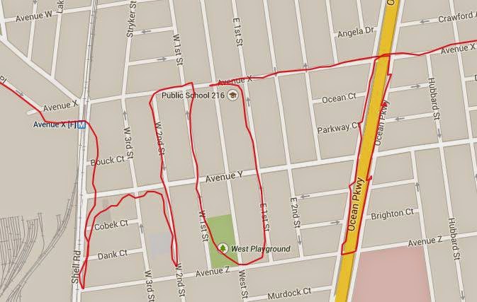
My accompanying text is
@NewtonRunning #RunningMakesMeFeel HOT, b/c I sweat easily, but, ladies, feel free to think "hot-looking" #promo
Nowhere does the contest rule says there will be points for humor but I couldn't help it. The rule does say
1) creativity and composition of word(s) and caption (33%), 2) originality of word(s) (33%), and 3) ability of word(s) and caption to portray how running makes you feel (34%) (the “Judging Criteria”).
Criteria #1 is easy to understand, #2 is kinda tricky, as there are only so many adjectives you can describe the feeling associated with running. Truly feeling it, and the word should not be crazy long that one would have to run marathon distance to make it. Criteria #3 is even harder to interpret, I guess it's all in the way you write your caption, with Twitter's 140-character limit and all. Instagram can be used also but I hate its square limitation. My GPS arts are usually rectangular-shaped, i.e. two distinct dimensions and not all four sizes are equal, so to satisfy Instagram I would have to do some extra work.
One day, instead of worrying about these restrictions of the Spell Challenge, I went out for a run with something else in mind to spell. Johnson & Johnson is a great sponsor of Charity Miles, which I in turn am a great supporter. While I can technically run whatever distance needed to spell out Johnson & Johnson, I decided to take advantage of the repeated name and only ran Johnson.

I took care to include the plus sign under Johnson. I know, it is not much of a plus sign but my restrain with GPS art is everything has to be connected. At the moment I did not consider running up and down East 3rd Street instead of making the loop.

My accompanying text is
@NewtonRunning #RunningMakesMeFeel HOT, b/c I sweat easily, but, ladies, feel free to think "hot-looking" #promo
Nowhere does the contest rule says there will be points for humor but I couldn't help it. The rule does say
1) creativity and composition of word(s) and caption (33%), 2) originality of word(s) (33%), and 3) ability of word(s) and caption to portray how running makes you feel (34%) (the “Judging Criteria”).
Criteria #1 is easy to understand, #2 is kinda tricky, as there are only so many adjectives you can describe the feeling associated with running. Truly feeling it, and the word should not be crazy long that one would have to run marathon distance to make it. Criteria #3 is even harder to interpret, I guess it's all in the way you write your caption, with Twitter's 140-character limit and all. Instagram can be used also but I hate its square limitation. My GPS arts are usually rectangular-shaped, i.e. two distinct dimensions and not all four sizes are equal, so to satisfy Instagram I would have to do some extra work.
One day, instead of worrying about these restrictions of the Spell Challenge, I went out for a run with something else in mind to spell. Johnson & Johnson is a great sponsor of Charity Miles, which I in turn am a great supporter. While I can technically run whatever distance needed to spell out Johnson & Johnson, I decided to take advantage of the repeated name and only ran Johnson.
I took care to include the plus sign under Johnson. I know, it is not much of a plus sign but my restrain with GPS art is everything has to be connected. At the moment I did not consider running up and down East 3rd Street instead of making the loop.
Johnson & Johnson, after a few minutes in Photoshop. Since Ocean Parkway is already highlighted on the map, I artificially lined it up when I stitched the original picture and its clone. I carefully cropped out the plus sign in the lower picture. Could be better, but good enough for illustration purpose.
Subscribe to:
Posts (Atom)