I recently learned about an acquaintance's Google Map listing running tracks in the New York City area. I contributed a few items and would like to look for more. I can see on the map that there's a track near Midwood High School and another near Grover Cleveland High School. Are they open to the public? What's the condition of the track surface? Is it lit at night? I myself run at Kaiser Park and Fort Hamilton High's tracks occasionally, but other than those two, the others in my area are not open to the public. Lafayette High, or whatever it's called these days after the break-up, is close by but too bad it's off-limit. A little further away is Abraham Lincoln High, near Ocean Parkway, same deal. Some day I can go visit Midwood High's track just to collect data. Grove Cleveland is too far, unless it's a long run, although I might have run on its track way back when I lived in the area. I clearly recall someone throwing a glass bottle behind me. I quickly exited the track as graceful as I could. It was back in the early 1990s. I lived in the area for only a year. My first car was stolen off the street and my apartment was burglarized, a TV and a VCR removed.
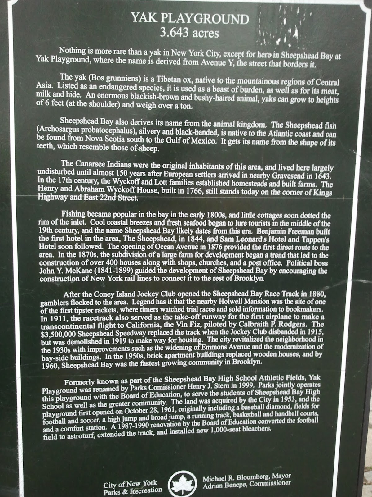
Today, just by chance I came across Sheepshead Bay High School and its track, on the same block with Yak Playground. At first I thought the name "Yak" came from some local civic leader's name but a plaque next to the park sign explained that it's from the adjacent Avenue Y. You know, A as in Apple, B as in Boy, Y as in Yak. The handball and basketball courts of Yak Playground were open, but the gates connecting them to the track were not. I didn't see any open gates along the other sides of the track. It is probably not open to the public.
Shortly past Sheepshead Bay High was the Gerritsen Peninsula and the Salt Marsh West Trail that was my destination. The last time I hit the West Trail, I exited it at Whitney Avenue. I planned to re-visit the trail some day with a running partner and do the whole trail, all the way to the beach area at the tip of the peninsula. Before that future trip, my plan is to explore the trail in sections. For today's trip, I thought of entering the trail at Allen Avenue and Burnett Street. I should have stuck with that plan, instead I went a little further south, toward the handball court. The street path seemed to end there, or at least too obstructed and impassable without a machete. I headed for the trail anyway, as the shrubbery was low and sparse enough to walk over or around. Before long I found the main trail and headed north toward Avenue U. I recognized the junction that would lead me back to Whitney Avenue's "exit". I took a little time out to go toward the waterfront but ended at the clearing and didn't go all the way to the waterfront. One thing I noticed is that between the trail between Whitney and Allen had many dips and rises. I took some photos but the change in elevation does not show that well. Once past Whitney, the path was pretty much how I remembered it. It rained a few days before so it was muddy and water-logged. I didn't even get out via the official trail gate on Avenue U. Instead, I went over the low railing on Burnett Street.
On the way back, my second purpose was to try to buy some powdered instant drink for my mother. "Sunway rye & cereal mixed powder", to be exact. It is available only at Chinese supermarkets and there were a few of those along Avenue U. I visited two New York Mart stores and two other supermarkets but none of them carried the product. Later at home I googled about the product and it seems it was already discontinued. No wonder I couldn't find it. At least during my stops at the supermarkets I collected data for a Google Map I'm compiling. The map is called "I've Gotta Go!" and lists public restrooms in the NYC area. I am sure there are other such maps out there, but this one will be mine, with info I personally collected, of places I personally visited.
Different sceneries, different purposes, I love my running routes!
 |
| Y is it called Yak? |
 |
| This is Y. |
 |
| Made it to the happy trail! |
 |
| I think I came through all that shrubbery. Low and sparse is good. |
 |
| Just beyond the clearing was the waterfront, seen as a sliver of white in the photo, but I thought I better head back. Maybe next time. |
 |
| The trail dips and rises, in the distance. |
 |
| Looking toward the beach. Or Avenue U. It looks the same to me. No, I was not lost. |
 |
| Some happy ducks gliding on the water in the background. |
 |
| Waterlogged path near the waterfront. |
 |
| If this is Florida, I would not dare to go this close to the water. Never know if some alligator would jump out of the water to grab me. |
No comments:
Post a Comment