Showing posts with label CityStrides. Show all posts

06 July 2025

STATEN ISLAND STRIDING

CitStrides.com is a web site that collects your walks and runs onto a map.  It's fun to look at the map and see where you have been to.  To make it even more interesting, you are ranked against other walkers and runners in the cities you have activities in, in terms of completing streets.  You can make things private and only you can see where you have been to.

When I first started using CityStrides, Brooklyn NY was my target.  Some guy named Dan was at the top of the list, I was in the top ten somewhere.  I was still an active long-distance runners and competed with a few others to maintain my spot.  All for bragging right!  On more than one occasions, I sailed past my competitor in the morning but she then inched past me, so I went out for another run, on the same day, just to beat her again.  At least temporarily.  What a silly thing to do, but it was so enjoyable.

At a past job, I traveled all over Long Island and the five boroughs of NYC.  I would either leave for work early or pull over at some strategic spot on the way home just to get a walk in, to complete a street or two.  At one point, I became the champion in Staten Island.  Years later and at another job in New Jersey, I started to cover areas in New Jersey.  Elizabeth, Rahway, Carteret, victories came with some work.  One day I happened to glance at my position in Staten Island.  What?  Since when did I get to #2?  And not just by a little, the gap was over 100 streets!  Time to regain my #1 title in Staten Island.  I don't know how long it took but around the end of June 2025 I finally made it.  I don't know what my challenger's plan is, I know I will keep widening the gap until it is over 100 streets.  Then I will re-visit the counties of New Jersey again.  I lik to see new areas, even if they are just people's home or public parks, nothing too exciting, but it's my thing.
07 October 2019

BRING NYC BACK

Bring it back, bring it back
Don't take it away from me because you don't know
What it means to me...

CityStrides recently had a major overhaul.  Lots of cities are now recognized so there is no need to individually request for them to be added.  Streets are now all real streets and not highways, buildings, bodies of water, etc.  Some streets that were mistakenly removed for being confused with Creeks or highway-style Turnpike were added back.  Examples are Cromwell Crescent in Rego Park and Union Turnpike, which is mostly an avenues with lots of traffic lights and red-light camera, but definitely not a real turnpike like Massachessetts Turnpike or Pennsylvannia Turnpike.

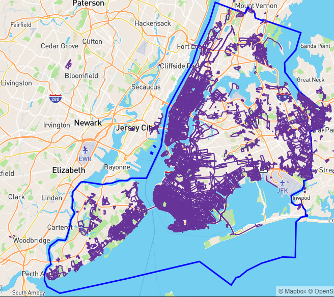
It was a bit scary for a few days to see all my ranking went low, like 4% complete instead of, say, 25%, for some given city.  I waited for it to be fixed but in the end had to write to Mr. CityStrides and now all is good.  Except that now there is no New York City (NYC) as an entity in itself.  In its place, not exactly the same, we have the five boroughs - The Bronx, Manhattan, Queens, Brooklyn, and Staten Island.  Plus, in Manhattan there are further breakdown of the the island-city into Manhattan Community Boards xyz.  I was really happy with my #1 position in NYC but now I have to settle with being #1 in The Bronx, Queens, and Staten Island.  All meaningless really, just bragging right, and nothing of real value.  Hopefully some day when things settled with this major overhaul, NYC will be brought back and the many Manhattan Community Boards will be abolished.  OK, it's not really Love of My Life we are talking about here but it's still nice to have it back.

20 September 2019

I'M WALKIN' HERE! I'M WALKIN' HERE!

And I sure walked a lot.  New York City is a pedestrian paradise, in some ways.  Yes, there are many rude, or even evil, car-drivers and then there are also many lawless cyclists ready to knock down pedestrians.  In general, the great thing is one can walk almost everywhere.  Or run, for that matter.  I used to be an avid runner, got up early in the morning to run a few miles, wash off the dirt, then go to work.  Then I started working at a job that required a car commute, a commute that would be so much worse if I didn't leave the house by a certain hour in the morning.  That meant no more running in the morning before going to work.  I was able to walk a lot, before work or after, or during lunch breaks.   I still ran on the weekends, or during the week on those rare days when I finished work early.

Wouldn't it be nice to visualize all that walking and running on one map?  Yes, and that's exactly what the web site CityStrides offer.  It is free to use, with some extra features if you pay for a subscription.  There are a few subscription tiers, I think anyone with a job should be able to afford the fee, just to support the work of the one man who runs the whole thing.

Below is my map of New York City, i.e. the five boroughs (The Bronx, Manhattan, Brook, Queens, and Staten Island) combined.  My activities only cover about 25% of the entire NYC so there is much work left to be done.  There is no fame or fortune to claim, just bragging rights among friends or friendly competitors.  A few people already covered the entire city, measured by some other means. The movie The World Before Your Feet chronicles one such feat.  The guy in that movie didn't have a full-time job and achieved the goal in about six years.  I have other obligations to satisfy so for now I am happy with my slow progress.


01 January 2018

THIS WEEK IN CITYSTRIDES: BROOKLYN, NEW YORK AT 20%

Happy New Year!

I started the new year by volunteering for my track club's handicap race and pot luck party.  One aspect of the event is a storytelling session after the race, with anecdotes about the club's past and current members.  I especially like the story about them interacting with Fred Lebow - yes, the Fred Lebow of New York Road Runners Club fame.

The last week of the year I had a few time-off days to burn, it was a use-it-or-lose-it situation.  Everyday of the week was cold but I wanted to maintain my tiny lead for New York, NY* in CityStrides so everyday I was out there running a few miles to add nodes.  Every little bit helps and currently I'm at 20% completed for Brooklyn and 9% completed for New York, NY.  Deep down I know that, because CityStrides round off to the nearest integer, I don't really have 20% and 9% but more of 19.x% and 8.y%, but it looks better this way.

In case you wonder, CityStrides has a little gadget at the upper left corner used for rotating or tilting the map.  I used it to achieve the view below.  Brooklyn, NY's height is longer than its width so that in order to include its northernmost portion, the area below Newtown Creek, I would normally have to zoom out further.  However, by tilting the map along the Z-axis you can see further without zooming out further.


* New York, NY in the CityStrides sphere means New York City itself, comprising of the five boroughs: Manhattan, Queens, Brooklyn, the Bronx, and Staten Island.  It does not mean the New York, NY as used by the United States Postal Service, which means just Manhattan and nearby islands plus Marble Hill, which is physically part of the Bronx but was originally part of Manhattan Island.

14 October 2017

SIT ON A POTATO PAN, OTIS AVENUE

I love it when two of my areas of interest intermix.  The title of this blog post refers to the phrase SIT ON A POTATO PAN, OTIS.  I don't know anyone named Otis or why he was told to sit on the pan.  It's just that the phrase is a palindrome – it spells the same from left to right and from right to left.  You'll have to ignore the comma and move the spaces around, of course.  I first learned about palindromes in a computer class for the BASIC language.  Recently I found a new love in CityStrides.com.

CityStrides.com let runners and walkers overlay a map of places they visited.  It seems like an impossible task – literally travel along all the streets in your town or places you visited.  In my case, that would be primarily New York City.  For some reason, out of the five boroughs, Brooklyn and Manhattan are also considered their own individual city.

Work and family constrains do not allow me to cover as much of my hometown Brooklyn as I want to so for now I try to maximize my coverage of NYC instead, as I regularly get sent to Staten Island and also travel through the Bronx.  The way CityStrides calculate percent completed has nothing to do with a street's length.  For example, let's say a city has a Main Street that goes for miles and miles.  Then there are also many streets that only stretch for a few hundred feet.  If someone were to focus primarily on completing Main Street while someone else covers all the shorter streets, guess who will have a better completion rate?  Yup, not the Main Street guy because by the end of the day, he may have just one out of the total streets completed.  Fair enough, really.

In trying to take advantage of this seemingly erroneous percent complete (which really is not erroneous), I try to cover all the short streets whenever possible.  Streets that are identified as Place or Lane are usually very short, one- or two-block long.  Then I came across Otis Avenue in the Bronx, in the Schuylerville area.  Imagine my surprise after walking along it and not finding it considered completed per CityStrides.  I searched for it in CityStrides and lo and behold there actually are three different Otis Avenues in New York City.  One in the Bronx, another in Queens, not far from Flushing Meadows Park, and yet a third one in Staten Island, just north of Miller Field.  The three locations are shown as series of green hexagons in the picture below.  Personally I think it is a mistake to consider the three Otis Avenues as three parts of one thing.  They just happen to share the name Otis and then also happen to be avenues.  New York City was not composed of the five boroughs – Manhattan, Brooklyn, Bronx, Staten Island, and Queens.  So at some point before the merger, streets were named independently and Otis Avenue happen to appear three times in the three different boroughs.  Just my semi-educated guess, of course.  CityStrides gets its data from OpenStreetMap, so if anything is to change it would have to come from OpenStreetMap.  Maybe I'll study OpenStreetMap and somehow I.D. the three Otis Avenues with suffix to make them unique to the borough and not considered part of "one street".  Highly unlikely I'll mess around with OpenStreetMap, as it seems to be a lot more involved than editing a page in Wikipedia.

Lucky for me, I happened to start participating in NYRR Open Run at Flushing Meadow Park.  I usually get there early and have time to walk around.  Otis Avenue of Queens was knocked out during my first run at FMP.  Next came Otis Avenue in Staten Island, where my son attends high school and I also work there regularly.  Easy for me, but I am sure the typical runner who have a job with a fixed office will find it hard to complete these erroneously longer streets.  Take that, Otis Avenue, go sit on a pot for all I care!


23 July 2017

CITY STRIDES PROGRESS REPORT - BROOKLYN, NY AT 13%

Captain America appears a few times, in the form of a pep talk video, in the movie Spiderman: Homecoming.  One of the topic he talked about is Patience.  Sometimes you need lots of it.

I have an intense interest in seeing my map updated in CityStrides. But I need a lot of patience.  It is nice that syncing happens transparently but there is a big backlog that resulted during the transition period.  I'm now at 13% completed for Brooklyn but I only noticed it today.  While I don't run in Brooklyn as much as I like to, I do try to target not-yet-ran streets and that strategy seems to pay off.  I just have to be patient and wait for syncing to happen with Strava, which seems pretty quick, but with Runkeeper the activities usually show up 24 hours afterward.  I usually use Strava for runs then keep track of walks in Runkeeper.  I don't want to inundate my Strava feed with the short walks that I do during lunch or at places of business that I visit.  Once the activities show up, you have to be patient and wait for the Streets Completed and Streets Progressed to be calculated.  A little more time then the city completion rates will be calculated.  In this case, Patience has its rewards.

There is a forum where questions get answered by James Chevalier himself.  I visit it from times to times to see what's going on.  If someone already asked a question that I have then I'll just wait for it to be answered instead of throwing out more of the same questions.

One interesting tidbit I recently learned is that city percent completion has little to do with street length.  Personally I like to run long, like from one end of town to the other, as far as possible without being late for work or other important aspects of life.  One long line by one long line I would have a grid created.  While the map then looks nice, if those streets I ran are long and I don't have them 90% completed, then they don't contribute to the percent completed.  On the other hand, if I find the many short streets and complete them, my percent completed will shoot up sharply.  It feels like cheating but that's how it's done.


Given enough time, those big zeroes for Streets Completed and Streets Progressed will be resolved to some non-zero numbers.  Unless I ran in some big parking lot just because I like to have lines all over the super-block.

New on the 13% map is "Adam" and his cowbell in Sunset Park, the inaugural Coney Island Creek 5K, which took place inside Kaiser Park, which I already ran many times, but thanks to a short pre-race warm-up and a post-race walk, a few more streets turned purple.

25 November 2016

CITYSTRIDES - WHAT MORE CAN A MAP-LOVER ASK FOR?

I love maps.  I sometimes spell words during my runs.  I started to spell the many Brooklyn neighborhoods but life got in the way.  At some point, I thought about how nice it would be to have all my runs/walks on one map.  Turns out there is such a tool and it's called CityStrides.  You connect your CityStrides account to Strava, MapMyRun, and Runkeeper then all your routes are in one map!  So wonderful!  Of course, in my case many of my carefully drawn routes are no longer recognizable because the many lines overlap but it's still a nice way to visualize one's activities.  I love the tool so much I actually update this blog after a multi-month hiatus!!!